I had a free weekend in April for a bikepacking getaway and I've been wanting to ride something in southern Arizona for a while. The Sky Island Odyssey route was high on my list, but right about the time I was going to start planning for that one, Kurt posted asking if there was interest in a route way down in the far southeast corner on AZ. Yes, please. A few weeks later Kurt hooked me up with not only the gpx file for the route, but a well put together waypoint file.
The route was a 255 mile loop through the Chihuahuan Desert spilling over to the Bootheel of New Mexico. Kurt sold it as a Tour Divide type of ride, which was exactly what I was looking for. Big mile days so I wouldn't need a bunch of time, read: vacation, to do the route. I sent out a feeler to see if anyone was interested in joining. A few were, but the timing didn't work out, but Robert is retired and always down for a good exploratory ride. We were set, drive south on Thursday afternoon, camp at the start a few miles northeast of Tombstone, then plan for two 100+ mile days to set up a short, early finish on Sunday. What could go wrong?
 |
| The Chihuahuan Desert is the largest desert in North America stretching from the heart of Mexico north into Texas, New Mexico & Arizona. Image courtesy of DesertUSA. |
On our way south we made the mandatory stop at
Seis Kitchen in Tucson. All fueled, we arrived at our camp location an hour before sundown. We were just inside the Coronado Nat'l Forest at the base of the Dragoon Mtns. It was windy, but soon died down. There were a few other campers nearby, but all was good.
 |
| Not a bad camp view, this will work. |
 |
| Sunset over the Whetstone Mtns. |
 |
| A final light show before the cool air sets upon us. Photo by Robert. |
I had a good nights sleep testing out my new Nemo sleeping pad, sure was nice not actually sleeping on the ground for a change!! It was a bit chilly the next morning, but we weren't in any hurry to get going so we poked around long enough until the Sun's rays lit up our camping area. We got rolling sometime around 7:30a. In the back of my mind I was hoping we could make the store hours in Portal, they close at 7p, but that was near mile 90 or so....
 |
| We joined the main loop here, by this cool Coronado Nat'l Forest sign. |
 |
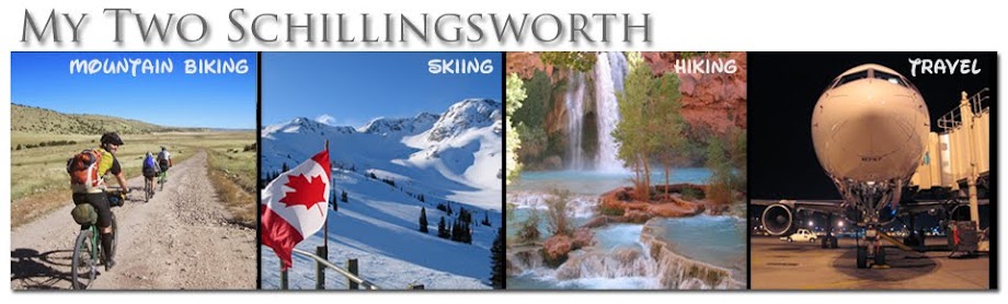
| In a blur, Robert was gone!! Making steady progress to Middlemarch Pass. |
 |
| Impressive view from the pass, Chiricahua Mtns. in the distance. Portal and the store are on the other side!! |
 |
| Robert taking notes for future rides. |
 |
| Rippin' fun descent from Middlemarch Pass!! |
 |
| Soon enough the hills gave way to fast gravel through the Sulphur Springs Valley. |
 |
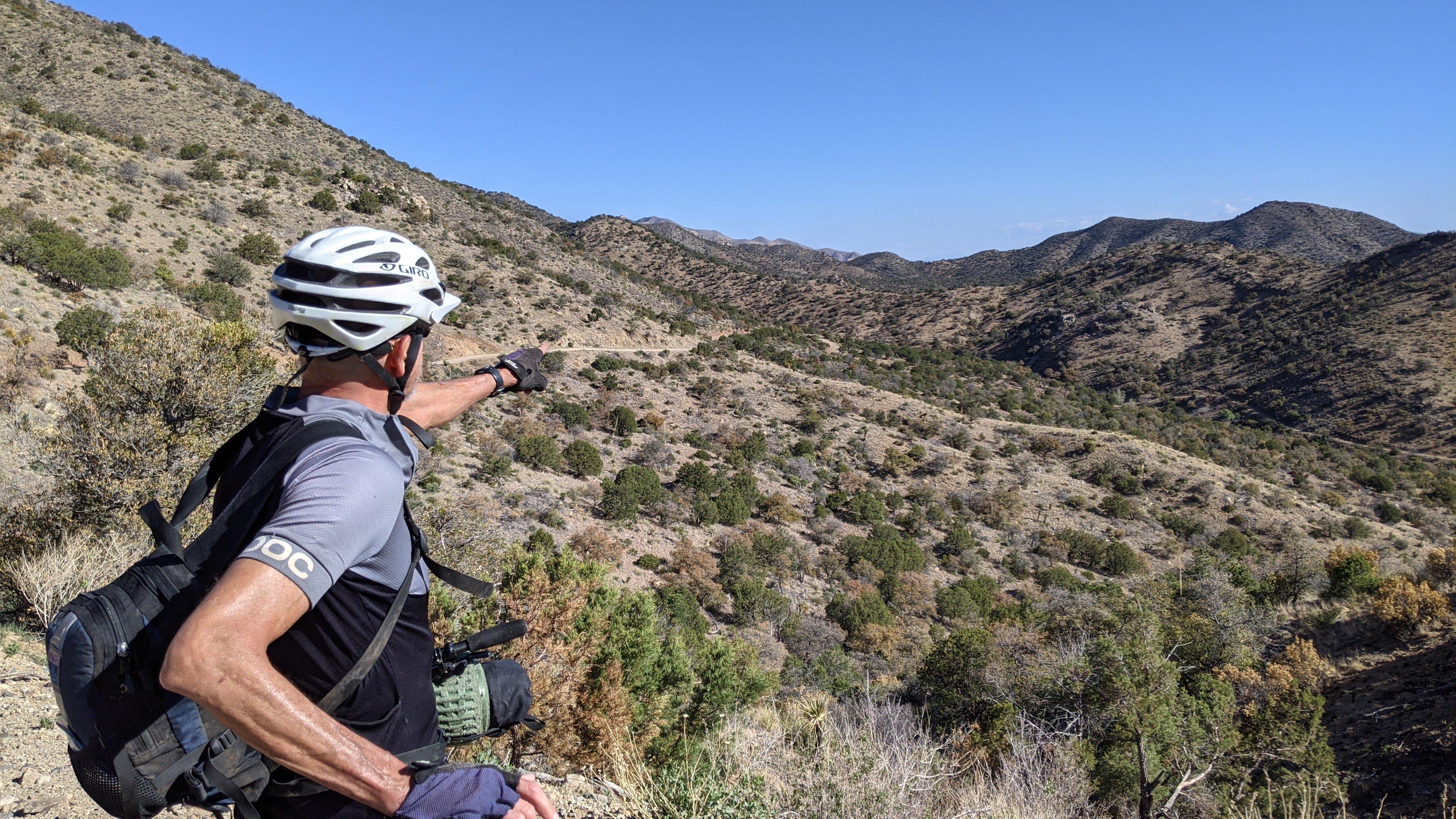
| First in a series of townsites we'd pass through. |
 |
| In the heart of Pearce, AZ. |
 |
| Pearce made its fame through gold & silver mining dating back to 1894. |
 |
| I love these old west townsites. |
 |
| Pearce Post Office opened in 1896. |
 |
| Some history. |
 |
| At its prime in 1919, the population of Pearce reached 1,500. By the 1940's it was a ghost town after the Commonwealth Mine closed operations. |
 |
| Cue the Monty Python & The Holy Grail lines... |
 |
| Quite the collection here. |
 |
| Tarmac-like dirt leading towards Mexican Hat & Turquoise Mtns. |
 |
| Arizona has some Big Sky country too, sorry Montana. |
 |
| One of the many mines in the area below Turquoise Mtn. |
 |
| Reservations were required, so we kept pedaling. |
 |
| This building appeared to be a two unit jail cell. |
 |
| A few of the small windows had bars and both rooms had an alcove with a hole in the floor. Photo by Robert. |
 |
| Bringing up the rear while I patiently wait for the calories to kick in. Photo by Robert. |
 |
| My view most of the morning: Robert far ahead of me, but I was hanging on. |
 |
| This was the third or fourth vineyard we passed. |
 |
| This sign lifted my spirits and the return to tarmac finally energized my legs around mile 40. I wasn't going to take it any longer. :/ |
 |
| Chiricahua Mtns. finally getting close, they had been our focus for hours. |
 |
| We opted to take the 1 1/2 mile detour to the visitor center to top off on water before climbing Onion Pass, the high point of the route at 7,600'. |
 |
| Most of the original settlers of the area rest here. |
 |
| Hard to imagine what life was like back then. |
 |
| While topping off water we enjoyed the birding show: Acorn Woodpeckers & Mexican Jays (pictured) |
 |
| I need to come back and explore more. |

|
| It was about 3:15p when we started up Onion Pass. I began to think we may make the store hours in Portal. It's almost all downhill after the summit. |
 |
| Wild Turkey sighting!! Photo by Robert. |
 |
| Robert caught me climbing way down in the shadows. |
 |
| It was cool enough at 7600' to break out the puffy. Photo by Robert. |
 |
| Such amazing views on the way down. |
 |
| We had to stop briefly to take in the sights. |
 |
| Some of the named peaks from the image above. PeakFinder app. |
 |
| More peaks sweeping to the east. |
 |
| Same view without the labels. I think I see Florida from here. |
 |
| Wild Turkeys were out in force, we must've seen two dozen on the day. |
 |
| May not be much, but water was flowing in a couple of locations. |
 |
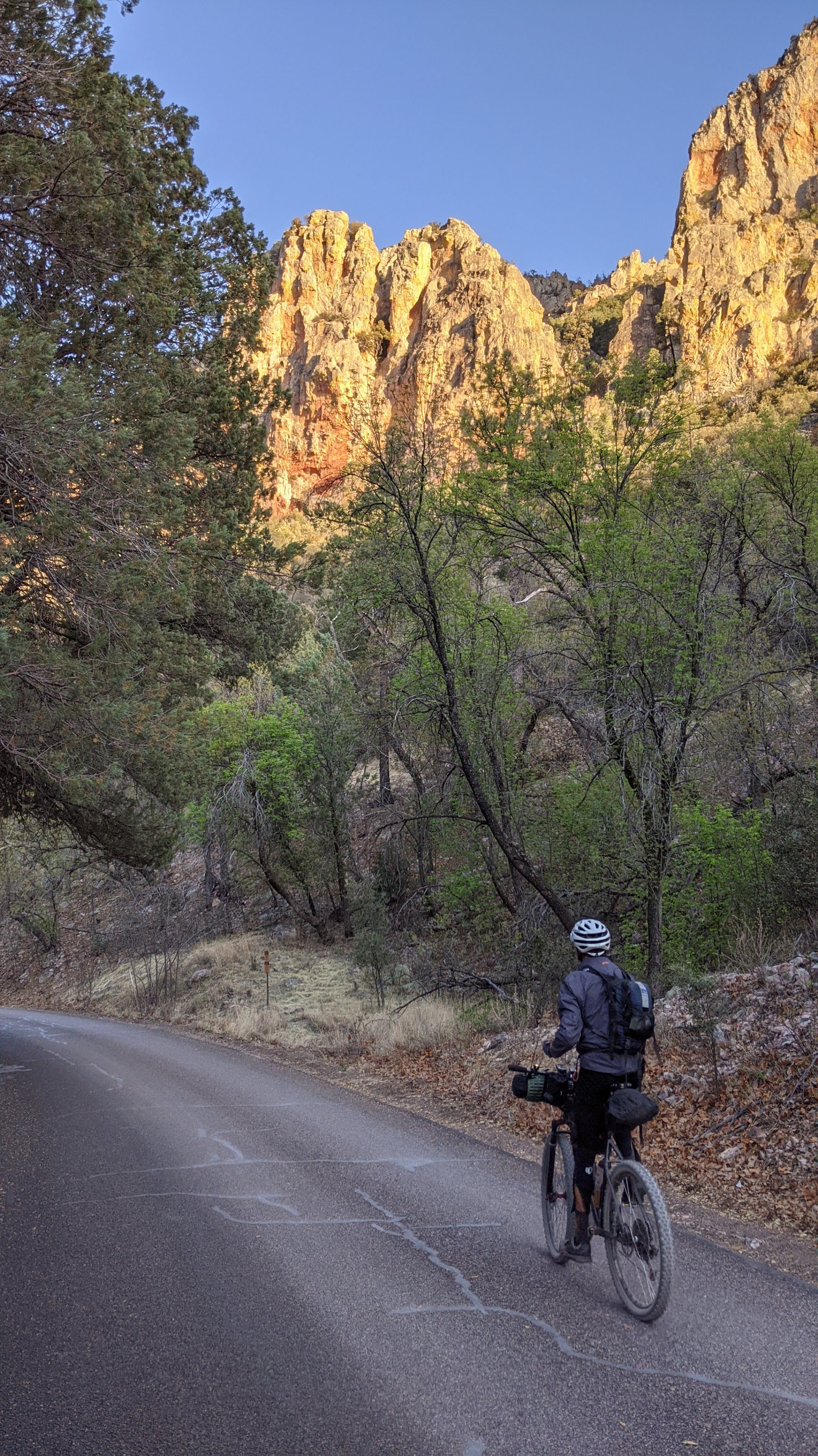
| Entering Cave Creek Canyon. A true highlight of the ride. |
 |
| Time of day sure enhanced the scene. Yowza!! |
 |
| Could be a painting or one of those 5000 piece puzzles. |
 |
| Stunning landscape at every turn. We kept stopping to take pics, but kept an eye on the time too. |
 |
| Robert reliving years past, sharing stories of old rock climbing adventures here. |
 |
| Hello there!! Spotted about a dozen deer today too and some Javelina. |
 |
| I think this is Cathedral Rock. |
 |
| Cave within a cave. |
 |
| We made it!! 30 minutes to spare at mile 93!! |
Inside, the cafe was tiny only a handful of tables, but most were spoken for. We grabbed an open table and as soon as we were handed menus, we both saw the green chile cheeseburgers at the same time. Yes, please. Couple of banquet beers too. Perfecto!! While we waiting on dinner, I did some shopping, topping off my drinks for the next leg of the ride.
 |
| Cool advertising. |
We still had 12-15 more miles we needed to knock out before making camp. Across the state line was a public lands area we were targeting and lucky for us most of those miles were downhill and all were paved.
 |
| I guess this is the border of AZ/NM. |
 |
| Up the road a bit we were officially welcomed to New Mexico. |
We had about 3 1/2 miles of slightly uphill miles along US80 much to my chagrin. We made the turn onto NM9 and Robert noticed some washes up ahead. We figured they would make a good camp spot for the night and almost as soon as we entered the public land boundary we found a dirt pullout leading down to a prime location. The high banked walls helped reduce the noise of the passing traffic, although there wasn't much in these parts. Even with the lost hour due to crossing into New Mexico it was only 9:15p. First day in the books, 105 miles down.
 |
| Perfect home for the night. |
 |
| Looking back towards the Chiricahua Mtns. |
We could already tell it was going to be a bit warmer today, still cool in the early hours, but not a cloud in sight. Robert heard an unsettling 'pop' in his knee while pushing up the steep slope from camp, something to keep an eye on, not exactly the wake-up call he was looking for.
 |
| We were now in the Bootheel of NM and would be riding around the Peloncillo Mountains. |
 |
| Not a fan of shoulderless pavement riding, but NM9 was deserted on this Saturday morning. |
As we rode towards Animas I was scanning the area and noticed the lack of good camping options, we sure found a solid site the previous night. We then came upon two ladies out walking on the opposite side of the road, no water, miles from anything. No idea where they came from, but they were friendly and said 'Good morning!'
According to Google maps the only store in Animas was listed as closed on Saturdays. Again, we didn't need anything, but it's always nice to grab a cold drink or ice cream whenever possible.
 |
| Stark landscape to the north. |
As we approached the gas station & store I could see a few vehicles parked in front, but figured they were simply getting fuel. Then a couple of people emerged from inside...was it open? Let's find out.
 |
| The Google was wrong!! Open: 8a - 12p on Saturdays and we were just after 9a!! Score. |
I topped off my Gatorade bottles and chowed down an ice cream sandwich. We were now about at the farthest point from the start or so it seemed. Our route would soon be turning south heading towards the borderlands.
 |
| Meep, meep! |
 |
| Farms and ranches dotted the landscape in a seemingly barren area. |
 |
| The stately Yucca, a prominent plant in the Chihuahuan Desert. |
We passed a sign indicating the upcoming end of pavement...the dirt never came. As you can see in the pic above, the asphalt looks relatively new. Surely, the second sign marking the end of pavement was correct...nope. Tarmac continued south...for 20 miles!!
 |
| Animas Mtn. would be our target for hours. |
 |
| 'When flooded, turn around, don't drown!!' Hard to believe there's ever that much water here, but it happens. |
 |
| Creeping by Animas Mtn. A lone filled water tank and a few Javelina. |
 |
| Javelina close-up, I counted three. |
We stopped for a snack break in a welcomed shady spot at a wash crossing. There was a couple there, also taking a break as they were driving north in their camper van. The fella asked us where we were heading and his eyes lit up when we confirmed our path over the Peloncillo Mtns. via the Geronimo Trail. 'You guys are in for a treat'. I always like to hear that. He then asked if the Border Patrol had stopped us since they had just pulled him over to scope out his van. Nope, they just keep speeding by us on this lonely road. I guess we don't look like the smuggling type.
 |
| Parched desert. |
 |
| A rare hilly section this morning. Photo by Robert. |
 |
| Tree sightings were almost sure bet to find water if needed. |
 |
| Here's our turn. As you can see, it's slightly uphill. Our route today began with essentially a 50+ mile climb on a grade like this. Just pedal. |
As the foothills approached, it was snack time once again. Might as well stuff down some calories before the main climb as you never know what the upcoming effort will truly be on a loaded bike.
 |
| My snack game is dialed, anywhere, anytime. Photo by Robert. |
 |
| Most of the named peaks are in Mexico, hence the 'Cerro'. |
 |
| Finally!! We get to enjoy a prolonged downhill. Photo by Robert. |
 |
| Robert drops in from the pass. |
 |
| Long, sunny downhill straight ahead!! |
 |
| Our stay in this section of the Coronado was brief, but we were now back in AZ. (The state line was unmarked about 1 1/2 miles over the pass) |
 |
| A sign before a blind turn let us know we were entering a 'residential area'. Perhaps at some point it was. |
 |
| All but a blip on the horizon. |
 |
| Make no mistake, you are being watched in these parts. |
 |
| The day was growing warm, not hot, but the lack of shade was noticeable. The US/Mexico border coming into view. |
 |
| Shade break!! |
 |
| Sonora, Mexico over yonder across the San Bernardino Valley. |
 |
| We thought we may be able to get water here, San Bernardino Wildlife Refuge, but the gate was locked. |
 |
| A few hundred feet north of the border wall sits this monument to the Mormon Battalion. |
 |
| Close-up view. |
As I stopped to take the above pics, I was setting my bike down and my Rev Grip pulled off the handlebars!! Normally, not a big deal, but these grips have small rubber inserts in each end cap that allows the grip to 'float' on the handlebars. Now, four of them were missing!! Luckily they are bright red and I was able to easily locate three of them, the fourth?? Who knows. I re-installed the grip and tightened the endcaps down, good to go.
 |
| We'd follow in close proximity of the border for a few miles on our way to Douglas, AZ. |
We both had taken inventory of our water situation, it was getting low, but we thought we'd have enough to reach Douglas without rationing, but if we found any along the way we'd filter. Sure enough, only a few minutes later we spotted a cattle tank off to the right with a group of black cows hanging out. Must be good stuff!!
 |
| Our brief desert oasis under the watchful eye of border surveillance. |
The cows weren't happy we crashed their party, a constant stream of moos cascaded upon us!! Move along, bikepackers!! We each added a liter of cool water for our short climb over the remaining pass to Douglas.
It was soon after leaving the watering hole I became really sluggish on the climb. Robert was gone and I needed to cram some calories in my face. Poptarts to the rescue. I was sitting roadside devouring the childhood treats when a border patrol truck towing a horse trailer pulled up and stopped. Three young agents were inside and the driver asked if I needed any water. I said, 'If you're offering, I'll take some'. He hopped out and handed me a couple bottles. Thanks!! I chugged one and dumped the other in my reservoir. I was a little surprised they didn't ask about our route, and they were gone. I eventually caught up with Robert before the pass.
 |
| Gentle climbing, with a few false summits, into the Perilla Mountains. |
Once again, Robert had pulled ahead of me on the climb when something caught my eye up ahead. From a distance it almost looked like a fire hydrant, but as I neared I could tell it was something different...
 |
| Roadside pony rides!! 25 cents gets you in on the action. |
 |
| Or, if you're a dare devil and big spender, go for the bull ride!! Now, where's that bull?? |
 |
| Over the pass the dirt turns to pavement and while downhill, we still had to pedal as the winds had picked up. Nothing horrible, but noticeable. |
 |
| Neighborhood cruising in Douglas. |
We both agreed that we wanted to make our resupply short in Douglas since we were aiming for a legal camp location, but that was still 20+ miles away and the sun was setting. We scanned the Google and found a Speedway gas station up ahead, we stocked up for the night and morning.
 |
| Perfect!! Right on route. |
 |
| Setting sun over the Mule Mountains (Bisbee) and fast riding through the Sulphur Springs Valley. |
Luckily for us, those 20+ miles were mostly flat, some pavement and packed dirt roads zigzagging through a maze of private property. We finally arrived at our camp adjacent to the Whitewater Draw Wildlife Area. The hum of a nearby turbine supplied the background white noise all night. We ended up covering 116 miles on the day and reached camp by 9:30p, not too late. That set us up for a short 40-ish miles back to the car the next day.
 |
| May not look like much, but it was a nice spot even with the turbine humming all night!! |
 |
| Swisshelm Mtns. |
 |
| Our day began with a brief stint on dirt roads. |
 |
| We soon popped onto Davis Rd. for a bunch of miles. The road wasn't too busy and all the vehicles gave us plenty of space which was very welcomed. |
 |
| Blooming Parry's Penstemon wildflowers. |
 |
| Even the dirt in mining country looks rusty!! |
 |
| Joining AZ80 for the final downhill miles to Tombstone. |
 |
| Tombstone: The town too tough to die!! |
 |
| We peeled off the route to resupply and check out some sights, like the OK Corral. |
 |
| Sounds delicious!! |
 |
| It was and a cool bottle. |
 |
| The Havok ain't no coward, right, Ike Clanton?? |
 |
| Historic Allen St. I like that it's dirt and closed to traffic. |
 |
| Tombstone Courthouse. |
 |
| We crisscrossed Allen St. on the open side streets. |
 |
| Another view down Allen St. |
 |
| Schieffelin Hall, built in 1881. |
 |
| What's this?? A gas line at mile 155?? Nice touch, Kurt. Hard to believe it was all rideable!! |
 |
| Back on Middlemarch Rd. to complete the loop. |
 |
| Closing the loop at the Coronado Nat'l Forest boundary at the base of the Dragoon Mtns. |
 |
| This was a great place to stage the route. |
 |
| Finished!! Photo by Robert. |
What a great route and I'm glad we rode it in a clockwise direction. I think our two big days were perfect as both camping locations worked out and we timed the store hours to a tee. A huge thanks to
Kurt Refsnider for putting this gem together and supplying the beta. Check out some other great routes of his over at
Bikepacking Roots, sign up for a free membership to strengthen our voice for public land advocacy.
Robert, thanks for being patient while I worked through a couple of ride struggles, thankfully they didn't last too long!! It's always a fun time riding/hanging out with you and I look forward to another fine adventure soon!!
 |
| Elevation profile for the entire route. |