Last year or so the Highline trail had a major rerouting project completed heading east from the Washington Park trailhead. Of course this is precisely where the
Arizona Trail (AZT) portion of the
Highline trail ends, so for now, the AZT section of Highline is still tough as ever.
I have been wanting to ride this fresh piece of Highline since last year and lobbed an invite to Mark. He was down after gaining the necessary family clearance. Then, like Mark does, he asked if I wanted to make it a loop instead of an out-n-back ride. Of course I did!! Who doesn't prefer a good loop, right? The caveat? We'd have to schlep our bikes up the Myrtle trail to gain the top of the Mogollon Rim. No big deal, I've done it before via Donahue trail. It's almost guaranteed to be 100% hike-a-bike, HAB, but only a mile long. I believe this is where you insert the phrase: 'How hard could it be?' OR 'What could go wrong?'. You get the idea.
Jason was also game for this brewing misadventure. I met up with him, Jennifer & Shelby at
Alfonso's Mexican food in Payson. Perfect way to get the day started.
 |
| Hmmm, was Alfonso's trying to tell us something?? |
It was our first time driving to the Washington Park TH. Ten of the fifteen miles out of Payson were paved to my surprise. There are a few trailheads along the way for hiking and more biking!! We met Mark and got ready for the first section of the day, the newly reworked Highline trail. I had a feeling the first 9 miles of our ride would be good. Turned out to be an understatement. The girls would peel off and do their own ride and fool around with Shelby's new drone.
 |
| A missing AZT sign added to the bike/sign photo collection. |
 |
| All smiles on Highline?? Strange, but true!! |
 |
| Mark taking in the views along bench cut trail. |
 |
| The Highline trail suffers from multiple personality disorder. It can't figure out if it wants to play nice, chew you up, look like Sedona or ride like Prescott. Either way, you get a taste of everything. |
 |
| Sedona here. |
 |
| Prescott here. |
 |
| Even a sprinkle of Flagstaff here. |
 |
| Dude Creek was flowing and had a nice deep pool to soak in if needed. |
 |
| Mogollon Rim layers. |
 |
| Thick, dense dark bit of trees crossing a drainage. |
 |
| So far all the switchbacks were very bike friendly. |
 |
| We were loving the cloud cover too. |
 |
| Cresting a saddle the trail opened up for a rippin' descent. |
 |
| This trail is going to be absolutely amazing when all 50 miles are reworked. Still a ways to go though. |
 |
| Looking back west towards the saddle. |
 |
| Entering a large burn area. |
 |
| The recent rains produced a thickening layer of haze. |
 |
| As we rode along we tried to guess where the Myrtle trail kicked up. |
 |
| I love seeing the layers of mountains stacked in the distance. It reminds me of western North Carolina. |
 |
| Bonita Creek flowing clear. |
 |
| The ferns kept the ground cover green. |
 |
| New signage and a spur trail near Bonita Creek. |
We had passed a lone rider doing an out-n-back ride and asked him where he turned around. He said he went to FR144, where the trail became 'unrideable'. That sounded about right near the 9 mile mark. Speaking of Mark, he's not one to turn down a climb challenge. Unrideable trail? Game on. He found out quickly that our trail beta was spot on. Time to push.
 |
| Seems I wore the correct attire today. #locorides #doepicshit |
 |
| Vintage Highline trail. |
 |
| For the next two miles we'd push up steep, rock strewn pitches, then ride down chunky fire breaks. |
 |
| Up we go. |
 |
| And back down. |
 |
| A harsh landscape for sure. Can you image 50 miles of THIS?? |
 |
| Not much indication here, but this is the Myrtle trail junction. Signage has been burned away, trail is barely visible behind Mark. Good thing we had our route loaded on GPS. |
We now had a good idea of where we needed to go. Up. The trail would top out near the saddle in the photo above. We were now 11 miles into our ride. The Myrtle trail was only a mile long, but gained about 1100'. Start pushing.
 |
| The trail corridor started wide, then became vague to non-existent. |
 |
| Marginal benchcut kicking skyward. |
 |
| Unfortunately the haze grew thick, obstructing our ever increasing views. |
 |
| Charred logs remain from the now long ago fire. |
 |
| The rocks were just large enough to warrant picking your bike up & over. Upper body workout!! |
 |
| You can see the Highline trail cut through the burned hillside to the left of the lone tree. This was the beginning of the Myrtle trail. |
 |
| Jason poking above the tall grass while Mark is camouflaged by the bouldery hillside. |
 |
| Good thing there was a reflector signaling a lefthand switchback!! |
 |
| Jason on the final pitch, two switchbacks ahead. I was whooped!! |
 |
| Look closely, you can see the Myrtle trail cutting across below the spine. |
 |
| The cliffs of the Mogollon Rim are the final step in gaining the high country of Arizona. |
 |
| The top is in sight!! |
 |
| Up top the walking continued as there were nothing but embedded babyhead rocks and no sign of a trail. |
 |
| Well, that was memorable!! |
We found some shade and took a nice long snack break. The 1 mile push up the rim took 1 1/2 hours!! I took my fair share of rest breaks along the way. I have some work to do to regain any fitness I had at the beginning of the year!!
We cursed all the OHVers that went buzzing by, not one offer of a cold beer!! Each one had a huge cooler too, how rude!! :p
At least now we were on the amazing FR300, aka Rim Rd. The next 7 miles or so would fly by quick.
 |
| I have a feeling FR300 will be a solid Tour Divide training ride. |
 |
| A few slight uphills, but mostly downhill flow towards the AZT. |
 |
| Top of the World views along FR300. Myrtle trail is on the shaded flank of the knob. |
 |
| General Crook trail blaze. |
 |
| Rider approved!! |
 |
| Sad. Came across this Bull snake with a busted neck, still clinging to life. |
 |
| 2 1/4 miles to go until the end, but how much would be rideable? |
 |
| A welcomed sight to those traveling northbound along the AZT. |
 |
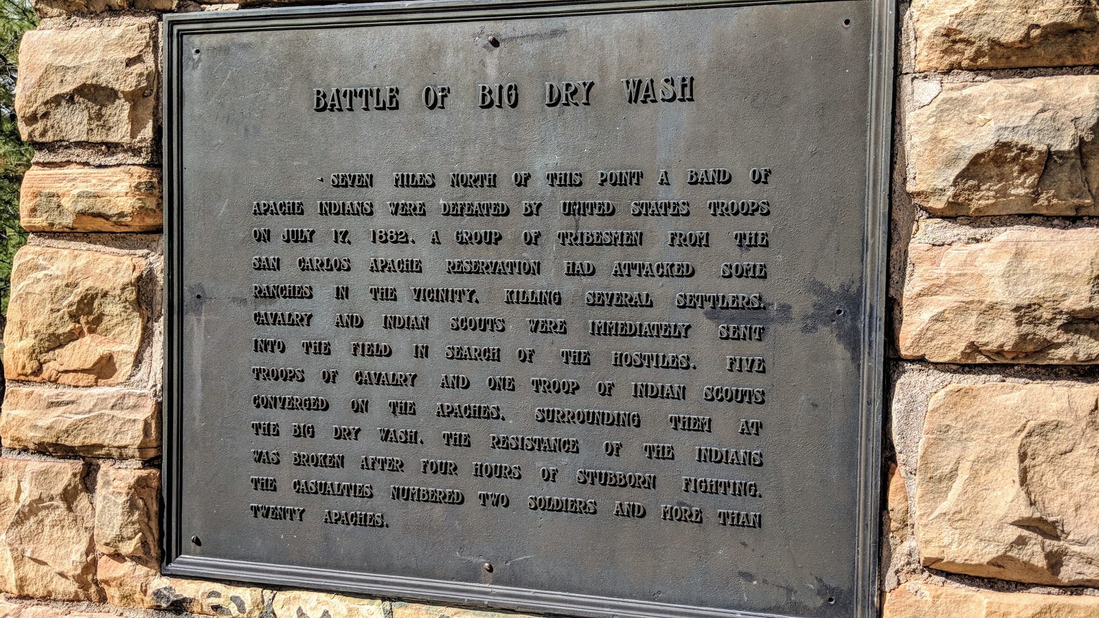
| It's hard to image scenes like this playing out here only 136 years ago. |
 |
| New signage along the descent making the split to the Tunnel trail more obvious. |
 |
| The fellas veer off onto the Tunnel trail chunkfest. |
 |
| This is why it's mostly hike-a-bike on the way up...down too in my case. |
 |
| A brief peek into rim country. |
 |
| More new signage at the opposite end of the Tunnel trail. |
 |
| I was looking forward to riding this particular piece of trail. Last year the ATA resurrected a long lost section of the Colonel Devin trail. This 'new' singletrack replaces a drab powerline corridor and crosses the East Verde River's headwaters a few times, notably on two impressive metal bridges that had been constructed hundreds of miles away at my buddy, Rob's, place. They were then transported and carefully placed in place. |
Always a good time hanging out and exploring new dirt with Mark & Jason. Sorry to Jennifer & Shelby for making you wait so long for us to finish!! The watermelon at the trailhead was so good!! Until next time, ride on...
Flyover
Route:


