The Goldfield Mtns still elicit a sense of adventure, mystery and exploration all leading to potential. The area is primed to become more popular as trails get some love in the form of brushing and minor reroutes. I try to find new-to-me dirt each time I head over there. Keep in mind, these are not system trails. They are primitive in nature, not much signage and they weren't built with mountain bikes in mind. That doesn't mean they aren't fun, just temper your expectations and ride with an open mind. The weather had remained cool and I had found some 'trails' on satellite that needed tires put to them. I ended up doing four separate rides over a couple of weeks in search of singletrack. I'm happy to report, not only did I find singletrack, but most of it was really good. Only a few dead ends, but that's to be expected.
Searching for Singletrack:
 |
| I staged for this ride off First Water Rd. on the east side of AZ88. |
All of these rides would remain inside the Tonto Nat'l Forest. The forest boundary forms the southern limits of the Goldfield Mtns. There are a bunch of OHV trails south of the Tonto as well.
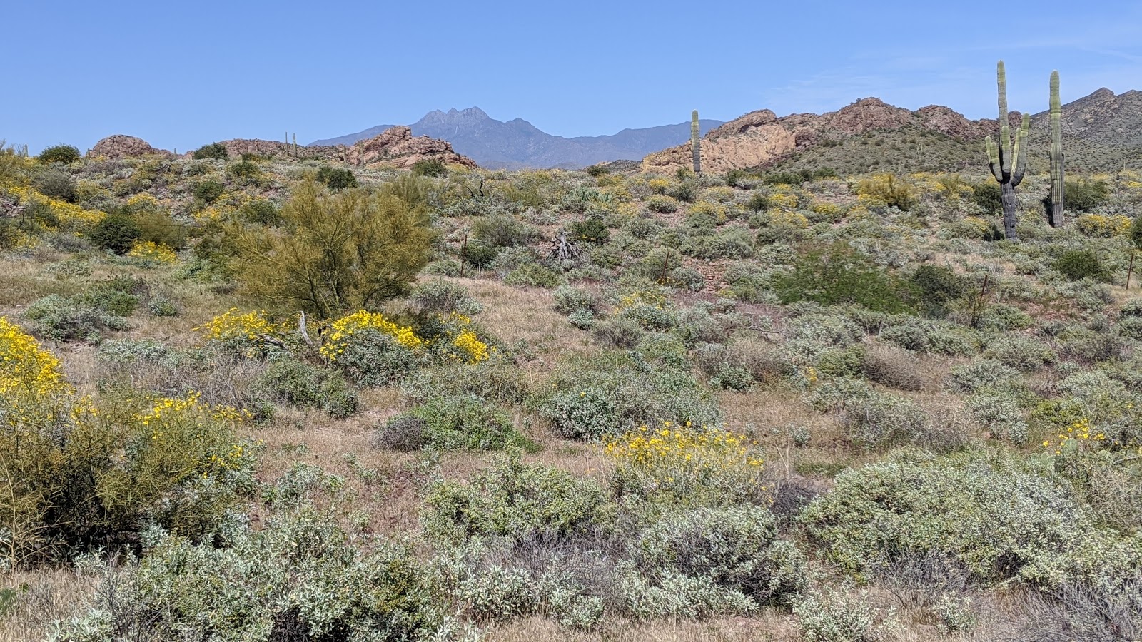
 |
| Four Peaks still clinging to a dusting of snow. |
 |
| I didn't have a route planned per se, but I did come armed with paper maps and highlighted areas that I wanted to check out. Old skool style. |
 |
| There are a few recognized trails in the area, they are numbered and beginning to receive signage. |
 |
| This one was practically a jeep road, but it was a nice up & over on a short ridge. |
 |
| This was a pleasant surprise, creating a loop option off Packsaddle Rd. dubbed Orohai. It became a little vague to follow for about 100 yards, but if you pay attention it's not too bad. More tires will help. |
 |
| Unbeknownst to me, I snapped this picture of Keyhole Arch (rock formation on the left). I wouldn't officially know about the arch until a later ride coming from the opposite direction. |
 |
| The Superstition Mtns. dominate the horizon to the east. |
 |
| More primitive horsey trails that rode fine. |
 |
| This was my favorite find of the day, a trail I named Jacob's Waltz after the famed Lost Dutchman. This trail rips down an undulating ridgeline. |
 |
| The tourist trap of Goldfield Ghost Town. Train whistle blowin' all afternoon. |
 |
| Found this little site with a survey marker on my way out. |
 |
| Lots of these throughout the desert if you look. |
 |
| It was a funhouse kinda ride. I think I mapped 8 new trails. |
Route:
Keyhole Arch ride:
For this ride I staged along Hackamore Rd. near the powerlines since the dirt road is slow going in my car. It's easier to ride it. Once again the goal of the ride was to map out some new trails and ride some that have become favorites, like the new reroute of Gold Nugget.
 |
| But first, a quick out-n-back on Boom or Bust to check out the recent trail work. |
 |
| Gold Nugget begins with this cool rock roll feature. |
 |
| It switchbacks up to here, then drops into the saddle area before a short hike-a-bike to the top. Perhaps another re-route is coming? |
I was surprised to run into a couple of hikers on their way out. They asked me if I was going to Keyhole Arch since it was right around the corner. I guess I was now. I couldn't recall exactly where it was located, but I had heard of it. They inquired about any other arches in the area, Anniversary Arch was the only other one I knew about, but that was miles into the rugged portion of the Goldfields.
 |
| Looking east from the saddle area I found the spur trail I was looking for... |
 |
| It wasn't much to write home about, kinda crappy actually. But it did connect the dots quickly. This trail was dubbed: Chunderstruck. |
 |
| I found the Keyhole Arch!! Barely visible here in the rock formation up on the hillside. |
 |
| Going slightly off trail, here's a better angle. |
 |
| Back on trail, the views out here are simply jaw dropping. |
 |
| Too bad some people feel the need to tag any and every site they can access. |
 |
| Lots of lichen. |
 |
| I poked around a bit and found a trail paralleling the jeep road down from the rock outcropping. |
 |
| More really nice singletrack. |
 |
| No target shooters today. Perhaps wearing bright colors is best. |
 |
| This vague connector trail showed just enough to follow. |
 |
| It cut a corner leading to this trail. |
 |
| On my way out, I came face-to-face with a rather thick coyote. We were maybe 8 feet apart, staring at each other. By the time I got my phone out, he walked off trail. He's in the middle of the photo, just below center. |
It was another highly successful ride mapping out new trails. Slowly, the network of trails was coming together, there weren't too many blank spots remaining, but still a few.
Route:
Parallel Universe:
I turned right around the following day and met up with Ezra for another round of Goldfield fun, I was feeling it. This time, we'd venture a bit deeper into the rugged stuff.
Back in February during the big group ride out here, we spotted a trail that had a bunch of potential, but didn't have time to explore it that day. Today would be the day. Again, we staged off Hackamore Rd.
 |
| Hopped on Gold Nugget to get things warmed up. |
 |
| Near the top of Gold Nugget. |
 |
| We took Orohai to Cottonwood Spring, which was flowing nicely. |
 |
| Sometimes the water would dip below the surface. |
 |
| Only to pop out again farther down the road. |
 |
| Terrain beginning to turn rugged, we must be close. |
 |
| Yep. Thankfully, this was really short. We wanted to do a quick lap on Brighton Ridge and this was the entry fee. |
 |
| Ezra heading back down for another stab at the climb. |
 |
| Near the top of the ridge, more slickrock type riding. |
 |
| Over the Hill & Down the Hatch is the name of this trail, this is the Over the Hill portion, depending on which direction you're riding!! It's steeper than it looks, hike-a-bike mode: ON. |
 |
| Near the top, we merge with the Anniversary Arch Loop. Some great riding up here. |
 |
| And a few optional B-lines if you look. |
 |
| Plenty of grippy rocks to roll on. |
 |
| The giant slickrock fin would be our destination. The trail then climbs up towards the knob. |
 |
| Anniversary Arch. |
 |
| The new trail started out fantastic. |
 |
| Then the pushing started. Looking across at Anniversary Arch. |
 |
| Looking back, some rideable sections here & there. |
 |
| Cresting the top after a steep push. |
 |
| This would make a cool camping spot sometime. |
 |
| Once again, amazeballs views. We were trying to come up with a good name for this trail. |
I mentioned how we were essentially paralleling a couple of other trails in the area. Then Ezra lobbed this out: How about Parallel Universe? Hmmm, has a nice ring to it.
 |
| Weaver's Needle & the Superstition Mtns. This would begin a series of steep downhills and short punchy climbs to the next ridgeline. I think there were 3 or 4 such areas on this trail. I walked some, rode some. I believe Ezra cleaned everything!! |
 |
| Nearing the end before it joins the Wash Trail. |
Parallel Universe is a difficult trail, but really cool. We could tell it doesn't see much, if any traffic, but was easy enough to follow. A little bit of trail work and this would really stand out. On our way back we stumbled upon another unmapped trail, one that wasn't even on my printout!! It was a shortcut to Frankie Goes to Hollywood and rode great. From there it was mostly jeep road back to the car. We tacked on Goldfield Fever West for one last bit of trail.
 |
| The view from FS 1356. |
Route:
Birthday Bash:
About a week after Ezra and I rode the Goldfields, I wanted one more fix before the heat kicked in. Plus, it was my birthday and I took the day off. This isn't really the place to ride when temps begin to soar due to the backcountry nature of the area. There was another unexplored trail I had yet to check out and a few others that were mapped, but I hadn't ridden.
I staged this ride off First Water Rd. and made quick work through the intermediate trails over to a trail I've been wanting to ride for a while: A Quiet Alternative. I was barely 100 yards into the trail and it was getting really difficult to find the route. I didn't have a track loaded on my GPS, so I opted to abort that trail for the time being.
 |
| Making my way into the heart of the Goldfields via ridgeline riding. |
 |
| Fine singletrack on Gold Daze. |
 |
| FS 1356 offers a nice view of Weaver's Needle to the east. |
 |
| This road rides surprisingly well considering the rugged surroundings. |
 |
| Yellow topped Brittlebush give way to a distant Four Peaks. |
 |
| Careful, you may find more sublime singletrack than you bargained for. |
 |
| The Wash trail isn't all wash. |
 |
| My junction to new-to-me dirt. |
 |
| I knew this was a short bypass loop, but it looked promising. |
 |
| So far, so good. |
 |
| The trail ended up being fine, a bit of sand near the end, but not a deal breaker. It dumped me out here, on Slice-O-Heaven. |
 |
| Brightly colored Hedgehog. |
 |
| There wasn't much of a B-line option here, back to the main trail. |
 |
| Yeah, that's better. Slice-O-Heaven money shot. |
 |
| Of course there's always a small price to pay to play. |
 |
| Capped the ride with a dead end spur trail to this cool overlook. |
Four rides in two weeks in the Goldfields finding a bit of everything the area has to offer. Believe it or not, there are still a handful of mapped trails that have yet to see my tires. I'll hold off until cooler weather for more backcountry exploration. I love that I can consider this area a backyard trail system of sorts as it's only 25 minutes from home. There's nothing like a good exploratory ride. Now, to expand the routes into a more logical flow and bigger mileage...
Route:
Here's the entire Goldfield Region on Trailforks: