The time finally arrived for my first
bikepacking trip. Where to go? For once, that decision was pretty easy. A few of us were originally going to drive down to the 24hr course and ride the
AES APC115 course over a two day period. Then my buddy,
Jonathan (
J-Bake), who lives nearby suggested an alternate starting point that made more sense. We would now meet up where the
Arizona Trail, AZT, crosses Freeman Rd. This put us almost in the middle of the 115 mile course right next to the AZT water cache. The new plan called us to ride the northern lollipop, 52 miles, along the Boulders/Ripsey segments first, campout, then ride the southern loop, 70-ish miles, including a spur through Oracle then onto the Antelope Peak segment.
The night before heading down,
Seron was still waiting on a replacement for a cracked chainstay, so he was out. Then Jonathan chimed in that he was a no-go for Sat. as well. So, Chris and I decided that we really needed to scout some of the route along with re-supply points near Oracle for the
AZT300. We packed up & headed south a little behind schedule Sat. morning.
Driving south from Superior is quite the contrast in views, on one hand there are the towering cliffs and canyons as you drop down to the Gila River, while at the same time you are driving past some of the largest open pit copper mines known to man. There's a raw rugged beauty in this part of the state. We soon found ourselves in Dudleyville looking for the connector to Freeman Rd. A few backtracks and fiddling with my GPS had us on the right path. We didn't realize we were going to have to drive
through the San Pedro River!! Luckily the flow was down and we splashed Chris' truck through the clear running water.
 |
| This guy was guarding Freeman Rd. |
10 miles of dirt later we were at the water cache. We started unpacking and loaded up the bikes. Although we'd be sleeping 50' from the truck, everything we needed for a remote campsite was going with us. I began putting bags on the bike, handlebars/sling, seat....where are my straps? Dig, dig, dig. Ah, crap! I left them in my car back in Gold Canyon, drat. Time to test out the new long one I was going to use as additional support. I rigged it up and it worked out fine. Then as I'm putting my framebag on, one of the missing seatbag straps magically attached itself to some of the velcro on the framebag - sweet! By dumb luck I was only down one strap, no worries. Ok, it's time to roll. Dang, it's already just past 10:30a and at our typical 5mph pace we were staring a nighttime finish right in the eyes. No problem, I have my lights. Chris? Oops, he forgot his, but had a small hiking light. Let's go.
 |
| Loaded & ready to roll. |
 |
| The start a grand adventure. |
 |
| Cool counter-weighted gate. |
 |
| It's not called the Boulders segment for nothing. |
 |
| Chris looking like a veteran bikepacker. |
 |
| We stopped to scout out Bathtub Spring on our descent to Ripsey Wash, the bees sure were thirsty! |
 |
| At the top of The Big Hill. |
 |
| The Hayden stacks in the distance. |
 |
| For all your climbing effort this is the payoff, Chad Brown declares this the best ridgeline in AZ!! I concur. |
 |
| Look closely and you'll see a thin slice of dirt climbing up to the left of the frame. That slice is the 4.5 mile climb up the Florence-Kelvin Hwy or F-K Hwy as I now refer to it. |
 |
| Globemallows in bloom. |
 |
| The Sonoran desert comes alive this time of year with a breathtaking array of color. Here golden poppie and lupines fight for superiority. |
 |
| A new AZT trailhead is in the works for the Kelvin area. |
 |
| Finally at the top of the F-K Hwy, whew! |
 |
| Desert sunset are really tough to beat, it seems like we get ones like this 4-5 times per week. |
We chatted with a couple of hikers we passed earlier in the day, wished them well on their journey to Kelvin the next day then continued putting miles under our tires until the sun fell below the horizon. We stopped to put on my lights with about 10 miles to go back to camp, but on the fast flowy Boulders segment. I would light the way & Chris would follow close behind. It worked well for the most part, only one endo by Chris. It was sometime around 8:30p with only a couple miles to go when we both spotted a black dog running around under the cover of a few mesquite trees. That's odd, we thought. I squealed my brakes while dropping into a wash while simultaneously picking up the dog owners' tent nearby! We obviously startled them and I shouted my apologies as we rolled along.
Finally back at camp, we were both exhausted. The ride ended up being a 10 hour day and it was almost 9p. We still had to cook up some grub before turning in for the night. The only real cheating we did with the truck nearby was to dive into the cooler for a couple of cold ones. How couldn't we, right?
We settled in for the night dozing off under the sparkle of a star filled desert sky and the faint howling of a pack of coyotes.
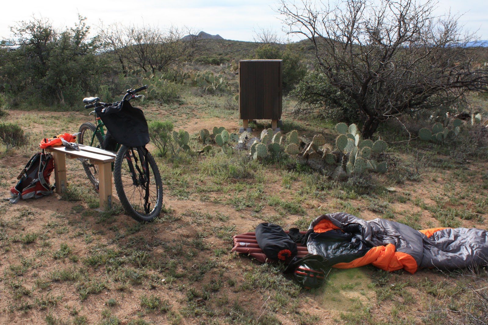
 |
| My bedroom for the night, next to the Freeman Rd. water cache. |
The next morning as I lay in the sleeping bag I hear a vehicle approach. It slows to a stop...it has a mountain bike up top....it's
J-Bake!! He's decided to finally do the Ripsey loop after a long time of finding reasons/excuses to NOT do it. He also did two remarkable things: 1) Brought us each a slice of supreme pizza from AJ's!! 2) Channeled his inner extreme couponer into 20 gallons of water for the cache!! We had added 6 the day before, so I helped him clear out the empties and we stocked the shelves. Jonathan was eager to get rolling so we didn't hold him up, soon he was off on his own adventure for the day. We were mulling our route plans as well.
We came to our senses and decided the 70 mile ride would not be a good idea on this day. It was already closing in on 9am, we hadn't really packed our things up yet, Chris was without lights and my battery was now near 50% of power. We opted for the safe choice and focused on the 13 mile loop down by Oracle. There was some new-to-us AZT to check out along with scouting for water sources and checking on store locations/hours.
We started our ride near the Circle K that will be used as a re-supply point during the
AZT300. The first few miles were on a mix of pavement & jeep road. We turned off the jeep road onto the AZT and what a hoot! Downhill grade, waterbar hopping all the way. The bottom of the hill spilled us into a place I recognized from a few photos over the years.
 |
| So this is the AZT sign I'm always seeing!! |
Soon after this picture we were riding along a hilly section of trail when we came upon 3 hikers up ahead. As we passed by one of them yells out 'I know you!!' I stop to turn around not fully recognizing the fellow in the wide brimmed hat. He says to his wife 'This is the crazy guy at work I told you about'. Ha!Ha! Rob!?!? What are you doing down here? He had just embarked on his personal bucket list of hiking/biking/horseback riding the entire
Arizona Trail. This was his first passage, the
shortest of the 43 at 8.3 miles. Good place to start. We chatted a few more minutes then were on our way once more.
 |
| Grinding it out on the SS. |
 |
| The Kanally Ranch house. |
 |
| Reliable water source!! |
 |
| Re-supply!! |
We arrived at the Kanally Ranch house in search of a water spigot, as luck would have it a park volunteer showed up minutes later and directed us right to it. The park is currently open only on Saturdays, but she confirmed to us that the water source would be available to AZT racers in a couple of weeks. We finished out the ride after a quick stop by the Oracle Market, good store hours, and a Red Bull.
A few things I learned on this outing: bikepacking is where its at. I need to thoroughly go through my gear list a couple of times and narrow down what I really need. Weight is a big factor out there. The bike handles great, just different. It's quite a bit faster on the downhills due to the added weight. Thanks Chris for making this a memorable adventure, we are first time
bikepackers no more!!