Memorial Day approached and with it a 3-day weekend & hall pass to go ride. There were rumblings on the
AES website about resurrecting the
Kaibab 130/200 routes. As luck would have it,
Chad made the call and scheduled a Kaibab Monstercross over Memorial weekend. Score. I've been wanting to check out the area by bike for a few years and my interest was really piqued last year when K and I made our first trip to the North Rim to view the
Annular Eclipse.
A bunch of the AES regulars traded emails and it became clear that no one was really all that interested in 'racing' the route(s). We all came up with slight variations of each course, but we'd all be starting from just outside Jacob Lake, AZ. My original plan was to do the 130 route without dropping off the plateau, opting to stay on the AZT as long as deadfall allowed. This was the main concern of the AZT through this part of Arizona, the trail is snowed under in the winter & we were arriving relatively early in the riding season. Plus, there is a large burn area the trail goes through that has been notorious for poor trail conditions. By the time I left Phoenix on Friday afternoon, Mark convinced me to alter my route to the southern end of the 200, making my route closer to 145 miles over 2 days. Most of the other riders would be camping the second night out at the North Rim Campground, I wasn't sure if I could make that distance in one push, roughly 95 miles. I kept my options open before the ride started.
Friday's workday couldn't go by fast enough, all my gear was with me ready to head north. I hit the road around 3:30p and thankfully the holiday traffic was a non-issue on I-17. A quick dinner stop in Flagstaff, watched a stunning full moon rise over the hoodoos on the Navajo reservation, and eventually pulled into camp around 9:30p. The ones who were there were already crashed out for the night. I opted to leave my gear packed & slept in the car, it was chilly keeping me awake most of the night, but I was resting well. I heard Chad pull in around 3:30a, then dozed off one more time before getting up.
Day 1: Forest Roads & Rainbow Rim
Camp began to stir around 5a with the first break of light. I really wasn't in a rush to get going, but didn't want to take forever either. Chris and I had planned to ride most of the loop together. A small group took off around 5:30a, then Chris and I followed shortly after 6a. A few minutes into the ride we were joined by
Kurt as we cruised the fast downhill miles.
 |
| Chad all smiles after his 1+ hour of power nap. |
 |
| Kurt cruisin' through an early canyon section. |
 |
| Trailside pictographs. |
We knocked out the first 15 miles in a little over an hour. The day was shaping up to be a beauty, clear dark blue skies & pleasant temps. Soon we began a gradual climb out of the sheltered canyon and were met with a stiff headwind.
 |
| Chris & Kurt during a snack break. |
 |
| Josiah & Mark caught up to us early on. |
After one of our snack breaks, Chris pulled ahead and rode with Josiah & Mark. Kurt and I would catch glimpses of them every so often. It was really cool to actually
ride with Kurt for an extended period of time, he's very plugged into the biking community along with his long list of riding accomplishments. Somewhere around mile 37 or so, he skirted off to check on a water source and to do a separate loop of his own. I only had a few more miles of forest road before hitting the Rainbow Rim trailhead.
Somewhere along a gradual 7 mile climb I began to not feel so great. It was that 'I'm in for a long day' feeling, nothing gastrointestinal, perhaps it was the elevation since most of the ride was between 8-9k. Whatever it was, by the time I met up with the other three at Parissawampitts Point I was beat. 44.5 miles of all forest road did me in?!?! At least now we get to ride on singletrack alongside the Grand Canyon, that made me feel better!!
 |
| Our first glimpse into the canyon. |
 |
| 18 miles of dipping in/out/up/down the canyon drainages. |
 |
| Some amazing pieces of trail. |
 |
| First real look into the canyon from the trail. |
 |
| Somewhere between Parissawampitts & Locust Points. |
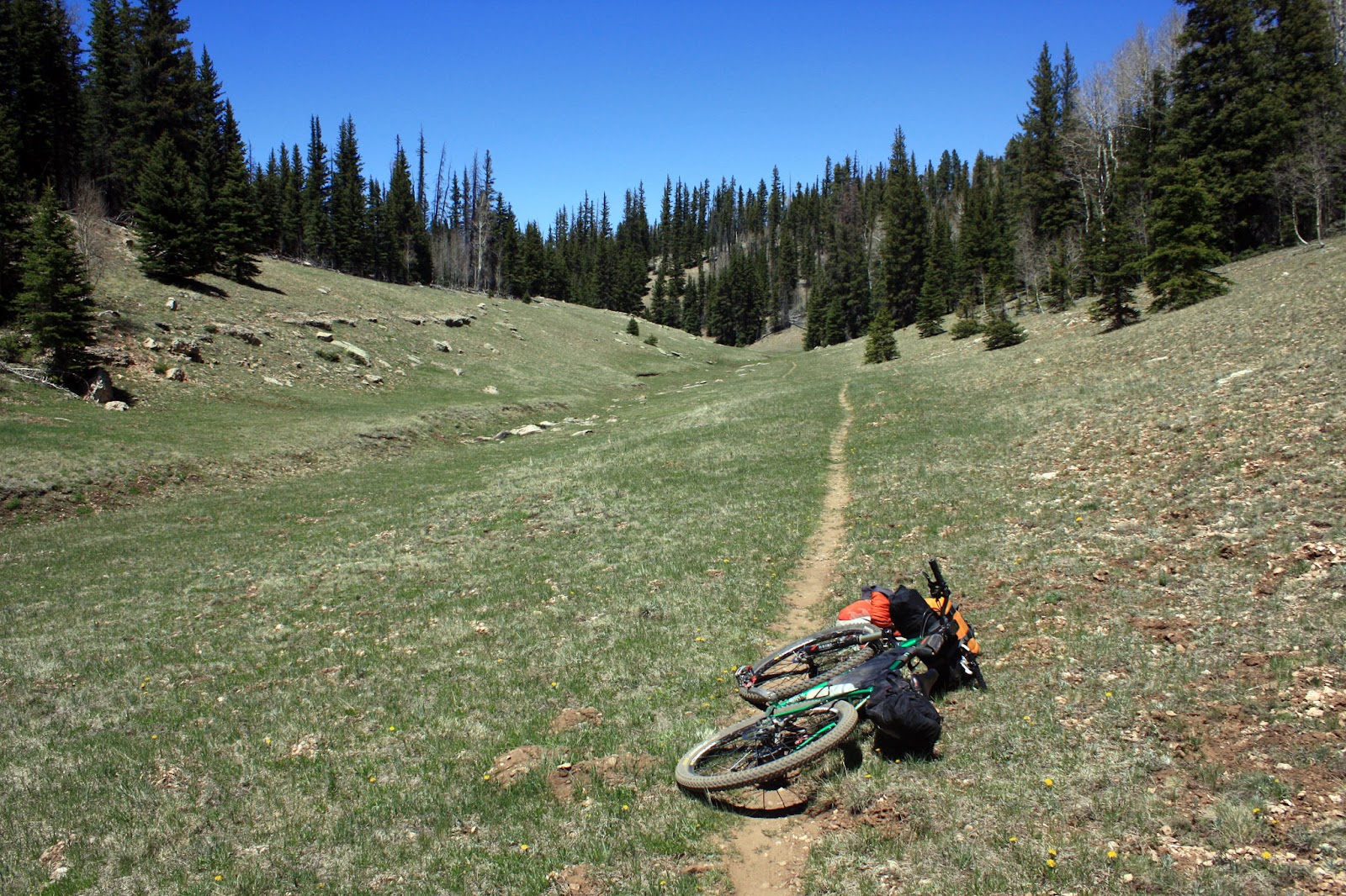
As soon as we departed the trailhead I was left in the dust by the others. The trail had just enough rubbly bits on it to make me work more than I really wanted to. It's a good thing I enjoy riding solo too! Somewhere along the twists & turns of the trail I could feel my back tire getting a little squishy. Not again I thought. I had fresh Stan's in this time, so I was reluctant to stop and pump it up recalling my Sedona issues from a few weeks back. Within the hour I relented and broke out the pump, hoping whatever was causing the leak would seal.
I came around a corner to find Chris putting the finishing touches on a tire slash. We chatted a bit about how far we planned on riding that day & soon came to a consensus about altering our plan to a more bee-lined approach to the North Rim Campground by following the 130 route. For me, it was because I was getting whooped by the elevation and Chris didn't want to risk his tire on more treacherous unknown trail. I didn't have that track on my Garmin, but I did have a snapshot of the area forest roads & topos loaded into the GPS.
 |
| This was Chris' first bikepacking trip too!! |
Chris caught back up to me as I pumped more air into my back tire, it was the last I would see of him until Sunday night. I got rolling again, now a very pedestrian pace, snaking my way over towards Locust Point. This day was becoming increasingly difficult, I almost wanted to be back on forest roads since I thought I'd be able to gain more ground that way. I decided that I was going to push on to the campground and hopefully make it to the saloon before the 9pm closing.
I kept fiddling with the GPS too, zooming in, zooming out, where does all this zig-zagging of Rainbow Rim end I wondered? I still had yet to reach Locust Point, but by now the trail had at least become more what I expected - fast & flowy!!
 |
| Locust Point. |
 |
| The wind kept the canyon views a bit hazy. |
 |
| The greens are more evident from the North Rim. |
There was a tour van parked at the Locust Point trailhead and during the rim ride I must have seen at least a dozen other bikers out enjoying the trail.
I was about to break out my pump for the third time, when it finally sunk in, add Stan's to the wheel already. Time for some quick trailside maintenance. 2oz of Stan's & CO2 cartridge later I was back in business, I was really hoping this was the last of my rear tire woes. I can't say I'm a big fan of the GEAX Saguaro tires after my recent flurry of issues. We'll see, at $27 from REI, it's tough to beat. Maybe I just got a lemon the first go-round.
I passed through North Timp Point and quickly came into the Timp Point overlook and the end of the Rainbow Rim trail. I must've looked like hell when I entered the trailhead because a couple from Flagstaff asked if I was ok & immediately offered up some water, gatorade & snacks!! I took them up on all three!!
 |
| 62 miles down.... |
Back on the forest roads & re-fueled I started feeling better. An hour or so went by and a white truck came at me, slowed to a stop and the driver asked if I was ok. It was Janice, Chris' wife, and daughters out checking on the riders! She asked if I had seen Chris, but I informed her that he was at least a good 45 minutes ahead of me. She had come upon Ray & Chad, then Josiah & Mark, all getting punished in their own ways. I passed along the info about Chris and I short-cutting the route a bit & his plans to reach the campground. I grabbed some water & M&M's from the SAG wagon and pushed on.
 |
| Deep into the Kaibab Nat'l Forest. |
I rode on for a bunch of miles, hit one short curvy HAB section then came to the spot where I would deviate from the route. According to my map & GPS, I would stay on FR223 until it came to a 'T' with FR270, take a right, then quick left over to the pavement of SR67. Easy enough. I think it was about 5pm or so when I continued on FR223.
Oh FR223, I despise you. Mark had warned me about the west->east running forest roads, as they all seem to climb endlessly to the plateau's high point somewhere around 9150'. FR223 was no different, nothing steep, just endless in sight and physically/mentally draining. The tough part was simply not knowing exactly where & when it was going to end. The road would almost flatten out, then rise up a short climb, flatten a bit, rise....repeat. For 8 miles or so. I was getting more and more beat down and started cursing at the road!! The shadows grew long and I knew I'd be arriving into camp in the dark. Could I still make the 9pm cutoff?
Mercifully FR223 came to an end at the junction of FR270. A sign pointed to the left 'SR67 4 miles', I needed to go in the opposite direction and my way was slightly downhill. I verified my initial routing to the pavement and proceeded down FR270 to the right. I swapped out some clothing as it was now getting colder with the sunset, hooked up my helmet light and I was off once more.
I was cruising down FR270 so easily that I blew right past the turn I was going to make, gah! I really didn't feel like backtracking uphill to find it either. The GPS indicated that FR270 would eventually meet up with SR67 a few miles ahead, right where the North Rim entrance station is located, perfect! I continued my downhill bliss when all of a sudden the road just
ended!?!? A forest cul-de-sac, nooooo!! I guess that's why the sign pointed left a few miles back!! I zoomed in on the GPS and could see I was only about 1/2 mile from the entrance station. Screw it, I'm going bushwhacking!! I could tell the road used to go through, but years ago it was plowed under, berms installed and trees were now shoulder high in reclaiming the forest. It was an easy downhill bushwhack which dumped me onto a powerline corridor. I could now see the entrance gate lights ahead. As I rode towards the lights I had a sneaking suspicion that there would be a gate at the end of the powerline, I was hoping there would not be a lock on it!! There was a gate, it was high, but luckily just a simple wire loop holding it closed, whew. If that gate was locked, I was camping
right there!!
The entrance station was now closed for the night as it was already after 8pm. I still had 12 miles of pavement to go and I knew I wouldn't make the 9pm closing time of the saloon. The good news: I was passed by 5 cars in the 12 miles to the campground. I finally rolled into the campground around 9:30p, gas station: closed, cafe: closed, camp host: closed, Coke machine: OPEN!! I rustled up a $1.25 for a splash of glorious carbonated nectar....nothing. Damn machine took my money & no Coke!!! Wtf. I stared at the machine for a couple of minutes....once again, $1.25 went in, this time Dr. Pepper....clunk. Winner. I gulped down the can then went about the campground looking for any bikepacking gear leaning on trees. It's a huge campground & I had no idea where to start looking. I must've have done 4 zig-zagged laps through it, but didn't find any of the others. Could they still be down at the saloon near the visitor center? It was worth a shot, so I rode the downhill 3/4 mile to the North Rim lodge, but no one was there. Back up the hill to the campground, one more lap through, nothing. Most of the campfires were now out as it was past 10pm. I needed to find a spot to put down and it was getting cold.
I pulled into a campsite with a young couple still hanging out by their fire and asked for a favor. They obliged, and let me poach their site with my one-man tent, heck they even offered me water & food!! I did have my stove, so at the very least I ate a warm meal before crashing out for the night.
Day 1 ride stats: 95.08 miles & 8589' of gain
Day 2: AZT
 |
| All the space I need. |
 |
| Kaibab squirrel!! |
I slept really well, straight through the night actually. There was no rush to get going as the general store in the campground didn't open until 7:30a. I got moving around 7:45, packed up & made my way over to the store. I see bikes!! Mark & Josiah were also late risers on this morning and I soon found out where the shared use biker/hiker camping spot was located. I would have never found it at night. They took off, I finished up eating breakfast and eventually guided my bike onto the bridle path leading to the Kaibab TH.
 |
| Kaibab TH, start of the AZT above the rim heading north. |
Mark reassured me that today was the day I'd see the legendary high alpine meadows. That's why I came up here, I had to experience it first-hand. This day was going to be easy by comparison to the previous day, only 50 miles to Jacob Lake, all AZT. The only real concerns were the condition of the trail, abundant deadfall is typically the norm this time of year. Reports had trickled in re: deadfall, but nothing to deter an honest effort. The trail through the Nat'l Park has often been rumored to be difficult to follow since the park rarely maintains it.
The first 1/2 mile was really cool, downhill through a small canyon then onto a forest road for a short bit. Soon I was in HAB mode up a short loose incline. I spied my first small patch of dwindling snowpack as well. The AZT continues on a utility corridor for a bunch of miles, wannabe singletrack, I didn't mind it. I was engulfed by tall pines and solitude, all was well.
 |
| Utility corridor. |
There were a few short HAB sections thrown in, a few downed trees, but I was able to simply ride around them. I only had to dismount for one tree.
I was cruising along about two miles from intersecting with the entrance station when my front tire began hissing at me. Gah! More tire issues. The small hole wouldn't seal and I was afraid my Stan's was a bit low. I was out of sealant since I already used my spare for my rear tire. My super glue / rubber cement had exploded back at the car so that wasn't an option. I had my spare tube, but I was reluctant to throw it in too quickly. I managed my way down the rocky descent to a few cabins outside the pay station. Time for the tube.
 |
| Tube install & ice water. |
A seasonal employee was living at the cabin and asked if I was ok or needed water. I grabbed a glass of ice water, but didn't need anything else. We chatted a bit about the route and he got me stoked about the upcoming stretch of trail. I yanked at least 7 huge thorns out of the inside of my tire, slapped in the tube and once again I was off, only now I was completely out of Stan's & tubes. I was a little anxious to say the least about my tire situation. Caution would rule the day for the next 37 miles.
 |
| A 0.1 mile detour led me here, North Rim lookout tower. |
 |
| Of course I climbed it!! A bit sketchy in 20mph winds, but cool views. |
 |
| Humphrey's peak in the distance. |
 |
| Leaving the Nat'l Park, meadows await!! |
 |
| The start of one of the finest 3 mile stretches of trail I've put tires on. |
 |
| 37 miles until Jacob Lake. |
The scene would repeat the entire day, ride through a grass-filled tree-lined meadow then enter the forest for some HAB fun! I really tried to be selective on my photo stops, but I just couldn't help myself, simply amazing terrain!! At one point I thought I heard someone yell at me from the forest, nah, there's no one out here. Before long I came to the east rim overlook.
 |
| New screensaver. |
 |
| This is REAL, right? |
 |
| Plenty of brochure style pics! |
 |
| Even the 2-track kicked ass. |
 |
| East Rim overlook. |
 |
| What a view. The start of the Grand Canyon. |
While I was snapping pics of the East Rim, Mark & Josiah come riding up. They had stopped for a trailside nap, these guys sleep a lot during their rides!! Josiah had yelled at me a few miles back, but I obviously didn't see him. We mostly rode together the rest of the way, it was nice to have some company for a bit.
 |
| Josiah on his tricked out rental bike!! |
 |
| Mark cruising along. |
We were all surprised a bit at the abundance of water availability. The plateau is notorious for being tough to find water, but this section of AZT had at least 4 or 5 good sized ponds to filter if needed.
 |
| Way steeper than it looks,even with Mark's incentive of free dinner, I had to stop. He cranked away in his little granny gear. I need one of those, my 22x32 was taking its toll on my legs/lungs. |
 |
| Snow!! Second and last sighting. |
 |
| Riding up to this pond I spotted a coyote so large I could've swore it was a wolf!! |
 |
| Mark & Josiah popping out of the trees. |
 |
| One of the few pieces of trail that was a bit difficult to follow. See that post out there in the meadow? |
 |
| Josiah cresting a climb and entering the burn area. |
We all stopped for a snack on top of the first burned out hill we came to. We were entering the burn area from a few years ago, one of the reasons the route gets moved off the plateau as the trail in years past had been unrideable. We were going to give it a go, but if things got ugly we could always bail out to the adjacent SR67 pavement. Mark busted out a root beer that he'd been carrying, so good, and we discussed the remaining trail sections & mileage. The sun was getting a bit low and we agreed there were still 18 miles to go with two hours of daylight. 9.0mph average with the last 5 miles being mostly downhill. I spoke up, 'I'm NOT putting my lights on today, no way!' We got moving knowing there was still one majar drainage to traverse.
 |
| Find the two riders. |
 |
| The red cliffs of Utah make an appearance. |
 |
| For AZT750 racers, this must be a welcomed sight: Utah! The finish line some 40 miles away. |
The burn area ended up being a blast. Fantastic contouring trail, short punchy climbs and zero downed trees! We eventually descended into the last drainage and there they were, a series of deadfall, maybe 5 in total. All within 200 yards of one another. HAB out the other side and now there are 10 miles to go.
By this time my photo stops put me back in solo mode for the finish.
 |
| One of a handful of access points to the AZT, aka trail 101. |
 |
| The sun is still shining with 9 to go. |
I was just about to the final 5 mile descent when I snapped a zip-tie on my fork. It took me a second to figure out what the noise was. I quick swap and the downhill was on. After about a mile of trail I was dumped out onto a forest road that winded down a canyon. It was now getting more and more dim, but I could still see as the miles ticked down. Just as the Garmin was chiming that the route was complete, I sustained a rear tire blow out!! I could have easily stayed on the forest road for another 1/4 mile taking it directly to camp, but I wanted to officially complete this passage of AZT. That meant another 1/2 mile down the trail to Hwy 89A. I tried pumping the tire up once and was only able to ride a few hundred yards before the rim was on the ground. Why not, I thought, a HAB finish on flat ground.
 |
| Trailhead at 89A & FR205. |
 |
| Flash required, but no helmet light!! |
I walked around the corner and strolled into camp where the others were gathered around a fire. Chris and his family, Kurt & Caroline, Mark and Josiah were all hanging out. After a quick change, Mark, Josiah and I headed over to the Jacob Lake lodge for some grub, but we missed the kitchen grill cutoff by 15 minutes. They make a rather tasty turkey & swiss though, couple that with a fountain Coke and all was good.
Back at camp we chilled around the campfire for a couple of hours. My plan was to get some sleep in the car before making the 6 hours drive back home. I wormed into my sleeping bag in the driver's seat and quickly dozed off.
Day 2 ride stats: 50.66 miles & 5120' of gain
I hit the road home at 5:30a, it was 35º as I descended off the Kaibab Plateau. The sun was making an appearance but the Vermilion Cliffs to my immediate left were shrouded in the early morning shadows. 10 miles down, the road bent to the north and the cliffs came alive as the golden rays danced on their splendid walls. I had to pull over and take it all in.
 |
| Vermillion Cliffs |
 |
| Rte 89A: you should drive here. |
A little over an hour later I was treated to magnificent views of the San Francisco Peaks. There was a bit of snow still clinging to the upper reaches of Humphrey's Peak.
 |
| Southbound on rte 89. |
 |
| Highest point in AZ, 12,637' |
I arrived back home around 11:30a and was greeted with temps in the low 90's. That is one nice thing about Arizona, cool temps are never too far away if the summer heat gets to you. I'll be back for more on the Kaibab. I already have two loops in mind, one loop covers the remaining two passages of AZT to the Utah border. The other will be the section of forest road I skipped out near Point Sublime.
Route:


Greetings! I'll be tackling the Kaibab Monstercross with a buddy this weekend. I uploaded your course to my Garmin, but it only recognizes the first 10,000 track points. Cuts me off at 133.98 miles. Do you know of a way to get around this? Thank you!
ReplyDeleteYes, there is a way to fix this. I use Topofusion as my gpx track editor/route planning software. If you don't have it there's a free fully functional demo version for download. Open the track, then using the pan (hand) tool, right-click the track and a sub menu will appear. There's an option there to simplify the track. Just put in a value of 9999 and it will simplify the track down to that number of points.
DeleteIf you happen to be on a Mac, TF won't work. Shoot me your email & I'll send you a simplified version tonight.
Also,
DeleteI'd recommend this route instead
http://schillingsworth.blogspot.com/2014/09/sublime-kaibab.html
Almost identical, except is goes to Point Sublime which is well worth the visit.
Wonderful! Thank you for the quick response! The Sublime Kaibab route looks incredible! We'll be sure to take that route. I do indeed have a Mac, so unfortunately the software won't work. If you wouldn't mind emailing me the simplified version (sub-10,000 track) of the Sublime route, I would be very grateful. Thank you! claytonwangbichler@gmail.com
Delete