The bike was packed & loaded, it was time to head out on my 3-day 215 mile loop from home, the Salty-Gila Tour. I pushed out of the driveway around 7:30a and before I could exit my neighborhood my lower back was soaking wet!! Drat. My bladder cap wasn't quite snugged down enough, but I didn't lose too much water. Onto the greenbelt portion of the route, time for a quick photo, nope. Camera was jammed. Double drat. At the last minute I opted to drag along the DSLR because my pack had so much room left over and now it's not going to work!?!? I was a minute or two from riding back home to drop it off since it wasn't working. Why lug it around for 3 days, right? I fiddled with it for a few minutes and suddenly it fixed itself.
 |
| At least I was able to dodge the sprinklers this time! |
I popped onto the canals and headed north making decent time. I was trying to settle into a new seat I was testing out, so far I couldn't get comfortable on it. My first set of trails would be at Hawes & the TRW trail.
 |
| Loaded bike, Red Mtn & my first glimpse of the Salt River basin. |
Over on the Hawes side of Power Rd I ran into a fella visiting from Missouri, I gave him some trail knowledge & recommended he go check out Gold Canyon while in town. It's nice to see visitors experiencing desert riding, it's like no other place.
I took a few minutes enjoying the view from the top of Cardiac (i.e. catching my breath!!) then proceeded over towards Twisted Sister and Wild Horse. This would connect me to my next trail system at Usery Mtn. Park. On my way through Secret Trail I noticed how the wildflowers were slowly disappearing, brittlebush were now in full bloom with some of the cacti beginning to show color. Summer is not too far away.
Near the end of Wild Horse I ran into a familiar face, it's Deanna!! She gave me one of those 'you're crazy' looks while asking what I was doing all loaded down. I think bikepacking is starting to intrigue her, just have to work on Walt to get them both onboard!!
 |
| Celine Dion is the secret to going fast?? Who knew? |
It was starting to get warm and I was close to my new go-to place for refreshments - Usery Mtn shooting range - so why not make a quick detour and get some cold water & a Pepsi.
 |
| Ice cold nectar! |
 |
| Oh, those crazy Duke boys!! |
Refreshed, I made my way up the backside of Pass Mtn via the backdoor wash entry. The climb up to the saddle wasn't nearly as challenging as I thought it would be loaded down.
 |
| The first scenic overlook on Pass Mtn. Bulldog Canyon in the background. |
 |
| Pass Mtn. saddle, ready for some downhill chunkiness. |
 |
| Well into the route, the Superstitions & Gold Canyon still seem far away. |
The Pass Mtn descent is a fun technical trail that will surely challenge you in a few spots. I was most pleased with how my bike setup responded. I had virtually no movement in my sleeping bag, I made certain to give it an extra cinching of the straps at the beginning of the day. The flat trails of Usery Park went by quick and I was soon back on the pavement of McKellips Rd shooting towards the Goldfields.
 |
| Short connector path to pavement. |
 |
| Entering the Tonto Nat'l Forest & the Goldfield Mtns. |
As soon as I entered the Goldfields I knew something wasn't quite right, my track had me going off in a direction I had never been. I wasn't sure what happened when I created this portion of the route & I wasn't familiar enough to just wing it since I was trying to get to Gold Canyon by 5:30. I stayed on the track, but quickly I was greeted with a steep/loose hike-a-bike section.
 |
| Start the HAB! |
There were a few moments of sketchy footing and on at least three occasions I slipped trying to get up the slopes. Up near the top I came to a 'T' junction, my track had me going to the left and UP, but to the right was a steep downhill with my re-supply store in sight out in the distance. I opted for the downhill & more cold drinks!
 |
| Superstitions getting closer, Gold Canyon is on the far right near the small hill. |
 |
| The Goldfield Ghost Town in the center is across the street from my stop at the Bluebird Mine. |
The downhill jaunt took me a little out of the way before dumping me onto AZ88. A couple of miles back up the road I passed by the ghost town and made my pitstop at the Bluebird Mine gift store. I shot Steve a quick text telling him to skip the Goldfield section and that gnarly HAB, he'd be hitting that at night.
 |
| Fun little tourist trap, steak house & fudge shoppe there too! |
 |
| More refreshments! |
 |
| Cool display sharing the mining history of the region. |
 |
| No Pepsi this stop, opting for the Powerade, fresh ice & an ice cream sandwich. |
I chatted with a few of the old timers who were hanging out playing cards before hitting the road once more. It was now 4:30, I had about 12 miles to go to Michelle's house and was about to hit a section of trail that was unfamiliar to me.
A mile or so up the road was the turn-off for the First Water Trailhead, this led me to the Peter Trail which would connect to the main north-south connector, the Jacob Crosscut Trail (JCT). Immediately after entering onto the Peter Trail I came upon this scene:
 |
| Almost candid camera-esque. |
I had to stop to snap a picture. Just then a girl came from the parking area figuring I would want to know what was up with the leather couch in the desert! Her fiance was now walking up and they were waiting for the perfect lighting conditions for their engagement photos, very cool. They were nice enough to let me borrow their scene for one of my own:
 |
| See? Bikepacking is easy. I just needed a beer in my hand!! |
I didn't want to leave! But I had to get moving. The JCT started out really wide, smooth & fast for the first few miles. Upon leaving the boundary of the Lost Dutchman State Park the trail began to wind a bit more, get narrower and of course chunkier.
 |
| Towering views of the Superstitions. |
 |
| Fast section of the Jacob Crosscut Trail. |
 |
| Fantastic views in every direction. |
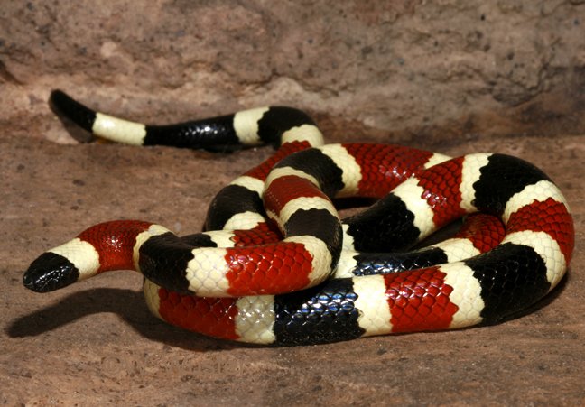
The next mile or so was a technical masterpiece, I wanted more of this! An occasional hop off the bike became more frequent as the trail notched up it's intensity. Before long it was time for HAB. Everything trailside in Arizona scratches you, the rocks are sharp, the cacti are everywhere, even most bushes are thorny. If I tried to get back on my bike to pedal it only lasted a short stretch of trail. It was really too bad, because the terrain out there is ripe for some sweet singletrack. At one point I stopped to enjoy the views and I spotted a
Coral snake behind me. I quickly grabbed my camera and tried to capture this beauty in his full black/red/yellow colorings. He must have sensed me just as I was about to hit the shutter and he was gone! Bummer. Back to the HAB.
 |
| A 'nicer' section of trail. |
I kept waiting for the trail to smooth out just a little, but it never really did. There was one ever-so-slightly downhill section that was akin to surfing on cantaloupes!! At least I was riding.
 |
| The golden hour begins to cast its gaze. |
 |
| Finally at the end of the Jacob Crosscut Trail, now onto the westend of Lost Goldmine. |
Off of the JCT, the Lost Goldmine trail was smooth by comparison. Now I can make up some time and get my loop in on the Cougar Trail.....I thought. A half mile in, it was back to HAB. Now the sun was beginning to get low and I was really hoping to leave my lights in the bag, for now. The miles seemed to drag on as I tried to push faster. Shadows became long, the temps were now pleasant and I was still not on familiar ground.
 |
| Nice view of Flat Iron in the Superstitions. |
There's a gate I recognize!! Cloudview Rd. was almost in sight, but by now the sun had set. So much for my goal of reaching Michelle's place by 5:30, I wouldn't arrive until 7:15!!
Pizza was waiting for me, so I chowed down & filled up both bladders for the long day tomorrow. I texted Steve again in hopes he'd also avoid the Jacob Crosscut Trail. He would be arriving in Gold Canyon sometime later in the evening.
Michelle was stoked to finally get out on a bikepacking ride, even if it was practically in her backyard!! Michelle, Tim and I set out for our campsite over at Don's Camp near the eastern end of the Lost Goldmine Trail. We set up shop in the amphitheatre, poked around the place a bit before settling under the stars with beer in hand. Does it get better? I dozed off sometime after 11pm, no word from Steve.
 |
| Not a bad place to be. |
I woke in the pre-dawn light, scanned the area for Steve, but he was nowhere to be found. We gradually got moving, my backside sore from that new saddle. What a mistake that was! Otherwise, I felt good. I checked my phone & saw a message from Steve, he was at the other end of Lost Goldmine and coming our way! We debated a bit on whether to meet him halfway, but there are a couple different was to get to camp, so we waited.
 |
| In your face wake-up call!! |
 |
| Waiting to hit the trails. |
 |
| Plenty of structures here in this oasis. |
 |
| Entryway. |
 |
| El Don's!! |
Steve arrived and was getting a bit low on water. We weighed our options for refilling & decided it would be easiest to backtrack to Michelle's for water/ice. We took off from her place around 8:30a, it was already starting to feel warm. I couldn't seem to keep my mouth wet, cottonmouth!! Bleh. Steve and I backtracked once more to pick up the route and started heading out of Gold Canyon towards Florence JCT.
We didn't get too far, a few miles in we stopped for some gear adjustment and I mentioned how I just wasn't feeling 'right'. I couldn't tell if it was the beginnings of dehydration or I just needed to eat some more. Steve concurred the feelings and after assessing our future route - 30 miles towards Superior, then the tough stretch from Picketpost to Kelvin in the heat of the day. We opted to call the route off, head back to Gold Canyon for something to eat, then ride home.
 |
| What do we do now?? Continue? Call it? |
We were both a bit bummed to not complete the full Salty-Gila Tour loop, but it was a wise decision. My seat was extremely uncomfortable, so I rode most of the 40+ miles home standing and mashing the pedals. I still ended up with 117 miles right out my front door, so all was good.
 |
| SanTan 202 fwy underpass. |
 |
| Almost home. |
Next time, I'll try this loop either in November or early March for cooler temps. I'll also slightly tweak the course to skip a couple of the rough spots.
This was the intended route:
This is what I rode instead:


hello, Mr Schillingsworth. I have a question that I am having a hard time finding the answer to by googling, so I'm hoping you can help me out since you seem to be an expert on the east valley bike trails. Can you tell me what trails/trailheads I'm allowed to access/park in without paying an entry fee? For example, I know the wild horse trail has a trailhead off of usury pass rd, and another off of power rd, and both have small parking areas without any signage at all. I'm just not sure if I'd be risking a ticket or a tow by parking there without a tonto pass or a usury park pass. can you tell me if either of these is required there? and if so, can you recommend other trails in the area where no pass is required? thanks
ReplyDeleteHey Bob,
DeleteYeah, there are plenty of free parking areas over there. I think I know the pullout area you described for the west end of Wild Horse, I believe you only need a Tonto Pass if you're parking at their facility, i.e. Phon D Sutton. I would think the roadside pullout is ok as long as it's not signed as 'no parking'. On the other end, I've parked at the Bulldog Canyon OHV staging lot. The Maricopa Trail runs through it and ties into Wild Horse a bit farther down the slope.
I also use the Park-n-Ride lot under the 202 freeway off Power Rd. for Hawes rides. If you have the annual State Land Recreation permit, the Gold Canyon trails have free parking at Cloudview TH. Hope that helps.