Picketpost?? Again?? Sounds like a broken record, but believe it or not, it was for a different route than probably anyone has done. Mike was able to join in the fun for this scouting ride. Our proposed route would take us through Arnett Canyon, continue east on the L.O.S.T. (Legends of Superior Trail) through Superior, up through the old Claypool tunnel, then wrap around to the north using dirt roads to link to the Arizona Trail at the base of Montana Mtn. Then AZT back to Picketpost. If all went smoothly & relatively quick, we had the option to climb Montana Mtn. for the full AZT run.
This ride was hatched a couple of years ago when the Locorides crew took on the Apache Tears loop, but the south end was so slow going we had to bail on the northern section.
 |
| We dropped into Arnett Canyon via the alternate trail from Picketpost trailhead. Still in full autumn splendor. |
 |
| The L.O.S.T. would get us into town. |
 |
| Finally got to check out the new tread, a very nice improvement. |
 |
| Some nice benchcut trail too. |
 |
| This was a welcomed find, a short spur trail connecting the L.O.S.T. to Circle K!! |
 |
| Quite the elaborate bridge spanning Queen Creek. |
 |
| Nice stonework on the north bank of Queen Creek. I'll have to come back when the creek is flowing. |
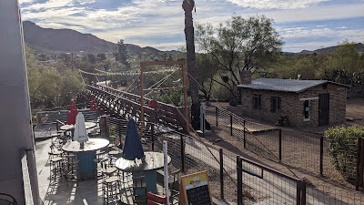 |
| Mike crosses the bridge and we noted the fancy bar & grille it led to. |
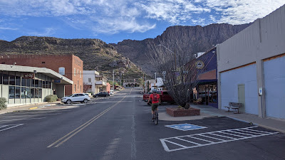 |
| Cruising through downtown Superior. Nice to see some renovation happening here. |
 |
| Making our way up Queen Creek Canyon on the old historic Superior-Miami Highway. |
 |
| We're far below the current US60. |
 |
| Legendary indeed. The convict highway. |
 |
| We found the rock from the plaque above. Neato. |
 |
| It didn't take us long to get high above the Superior water tank. The climbing grade was very rideable. |
 |
| Terrain becoming more interesting. Watch for falling rocks!! :o |
 |
| The old Claypool tunnel. |
 |
| So glad this is still open to bikes & hikers. |
 |
| Don't know who Mr. Don is, but RIP. |
 |
| End of the line for the L.O.S.T. New US60 tunnel here. |
Now for the sketchiest part of the route: 2 miles on busy US60, no shoulder. At least there is a passing lane so vehicles have a bit of wiggle room and the sight lines are decent. We broke out our blinky lights as well. Let's get this over with...
 |
| We reached our dirt turnoff without incident, but were both very glad to be done with those 2 miles. |
 |
| Ruh-roh. Hmmm. This didn't show on any map....recalculating. It's too bad because the road we were on was a great riding surface. At least we only had to backtrack about a quarter mile. |
We spotted a small sign indicating a public route, so we figured many others ran into a similar situation. If we couldn't find a way through, it was still easy enough to turn around.
 |
| Making my way up a long gradual climb. Photo by Mike. |
 |
| Downhill walk of shame after wiping out twice!! Photo by Mike. |
 |
| At the bottom of the treacherous downhill we found the nice road we intended to ride. Back on route. |
 |
| We were ready to cover more miles a bit quicker. |
 |
| This lake filled open pit was fenced off, but a bit surprised this wasn't part of the closure we had to ride around. |
 |
| Up we go. |
 |
| We encountered one Jeep going the other way, that was it. Curious to know if they made the climb up that loose grade. |
 |
| Picketpost Mtn. looking tiny. |
 |
| Picketpost Mtn. in the right of the V-shaped valley. B&W for effect. Photo by Mike. |
 |
| Not much of a gate for mountain bikers. Photo by Mike. |
 |
| It was high enough to crouch under!! Photo by Mike. |
 |
| Nearing our high point of the ride around 5100', Superstition Mtns. to the far left, Sierra Anchas to the far right. Looks like our route cutting down the near hillside too. |
 |
| Some really good riding up here. |
 |
| Here's a panoramic view from left to right over the next few photos. Some interesting names. PeakFinder app. |
 |
| No labels here, just Picketpost dead center. |
 |
| FS650 can be seen cutting through the valley below. Our exit strategy. |
Route:


No comments:
Post a Comment