The Palisade Plunge has been in the works for over 10 years and Phase I recently opened. I figured if I was anywhere near the area, I'd check it out. For some of the backstory on what it took to become a reality, check out this article.
My buddy, Maxwell, lives nearby in the summer and I reached out to see if he was available to ride. He was and we opted to meet at the bottom and self-shuttle, you can legally park your car at the Wild Rose Recreation site. From there it's a bit over a two mile climb up a well graded dirt road to the trail junction.
When fully complete, July 24th is the anticipated opening date, the Plunge will be a 34 mile, 6,000' descent off the Grand Mesa to the Colorado River. Our ride would be along the lower 17 miles of trail. Seemed that would give us a good taste of what's to come with the full opening.
It took us about an hour to drive up to the drop zone, maybe we should've paid for a shuttle. Hmmm. Anyway, it was around 2p when we finally started pedaling and it was going to be warm down at the bottom, but we're both desert rats, so we weren't concerned about the heat.
 |
| 2.2 miles up Lands End Rd. to get things started. |
 |
| We were greeted with this at the trail, the upper section, still under construction until late July. |
 |
| Maxwell's photo op at the start. |
 |
| My turn. |
 |
| Here we go!! |
Almost immediately the trail pointed downward. Fast, bermed turns through the forest. YESSS!!!! It was fairly steep too and not knowing the trail, I was on my brakes a bit more than I needed to be.
 |
| The trail leveled out enough to snap a pic of Maxwell. |
 |
| We thought we'd only be in the aspens for 5 minutes, but it turned out to be a few miles worth. Although we started at the halfway point of the Plunge, it was still over 9,000'. |
 |
| Still cruising through the greenery. |
 |
| Don't know how reliable this is, but Whitewater Creek was flowing good!! |
 |
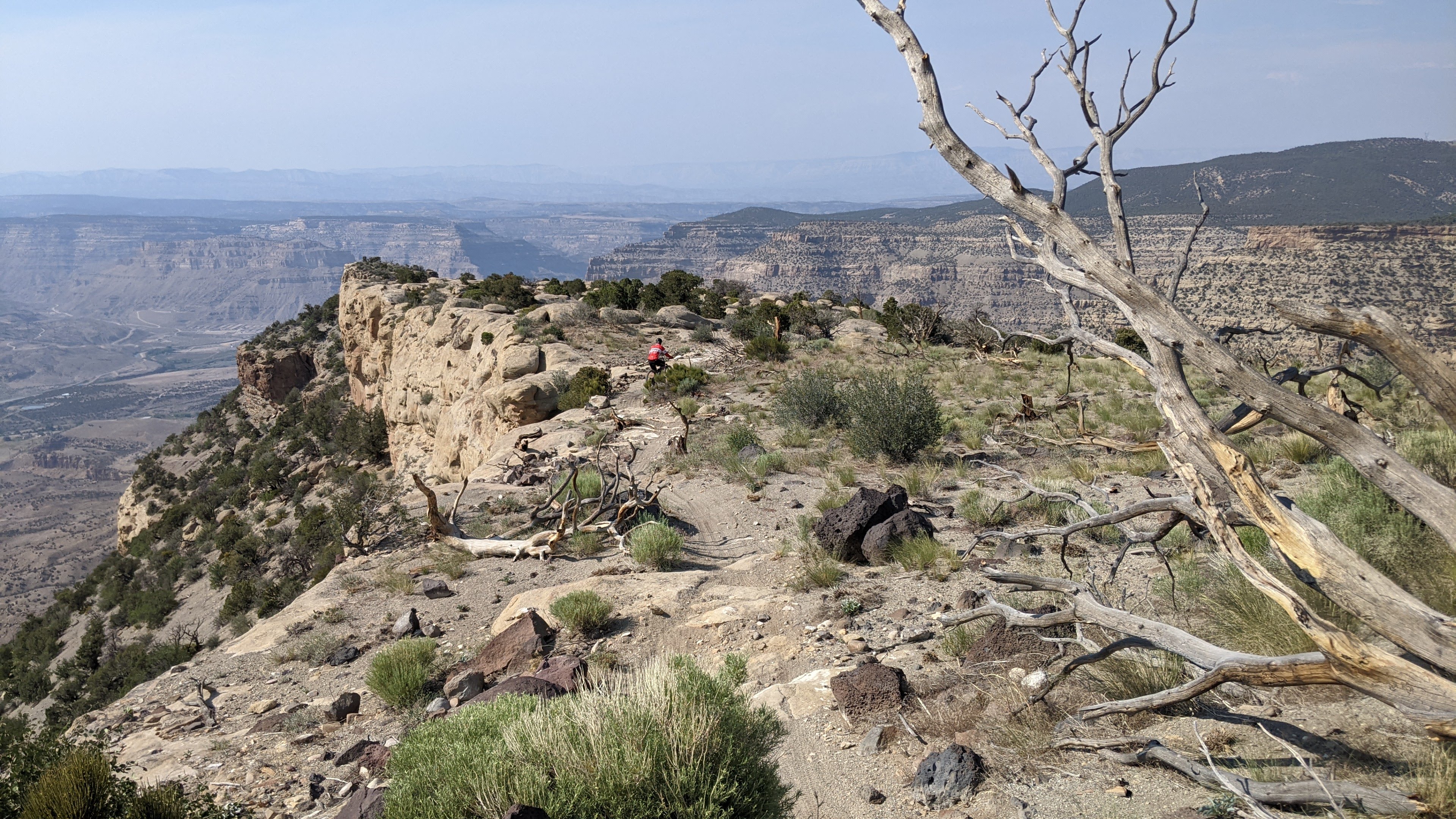
| So far, we were only getting glimpses of the valley floor. |
The grade had relented from the beginning of the ride, there were some climbs mixed in. The trail had plenty of rocks too, larger ones, but flowed well. It was the type of terrain that was fun to ride, yet demanded attention else a pedal strike.
 |
| We were glad to have the shade for the upper half of the ride. |
 |
| Grand Valley opens up under the smoky haze. |
 |
| These first few miles were a hoot and we still had a long way to descend. |
 |
| There were a few of these signs along the way. Tons of useful information. Well done. |
 |
| Entering The Blowout area. |
 |
| There were a few sections of sand, the fine powdery kind. |
 |
| We start the transformation to the upper desert terrain. |
 |
| It was fun trying to guess where the trail would go. In this case, we'd climb to the cut high on the approaching mesa. |
 |
| Halfway around The Blowout. |
 |
| The 22.8 mile marker will be from the top portion we couldn't access. |
 |
| The short uphills were beginning to stack up. |
 |
| Lots of well contoured trail too. |
 |
| Perfect spot for a benchcut trail. |
 |
| Steep, loose and sandy = hike-a-bike!! |
 |
| Pic doesn't truly convey the gnar factor here. Photo by Maxwell. |
 |
| In spite of the dry conditions, the trail had packed in nicely for the most part. |
 |
| Tame section!! |
 |
| I hope my next ride here has better air quality. |
 |
| We crossed over a small saddle giving us views to the northeast now. |
 |
| Now we're in Moab!! Fun slickrock area, complete with white dots to follow. |
 |
| Slickrock on the edge. |
 |
| Seemed like a good place for a snack break. Colorado River still waaay down there. Book Cliffs on the far left. |
 |
| My car is parked down near the bridge over the Colorado River on the right. |
 |
| That's a loooong drop on the left, but so far the exposure hadn't been bad at all. |
 |
| We could tell our plateau was running out. |
 |
| But first, some boulders and slickrock to play on. |
 |
| Five miles to go and we still needed to descend 2,600'. I see a lot of switchbacks approaching on the map!! |
 |
| Warning of things to come... |
 |
| Will rain & riders pack this section of trail in?? Time will tell, but the amount of fine sand wasn't helping our confidence as the terrain steepened. |
 |
| Maxwell pointing out the trail on a lower plateau. This section was steep & loose, but a lot of time went into building it. Look at those rock retaining walls!! We walked a fair amount in this area. |
 |
| We'd be riding the squiggles in the foreground of the mesa, dropping down the canyon on the far right exiting near the two bridges. |
 |
| A more stable section, but don't ride off tread, you may not stop. |
 |
| The routing was impressive to say the least as we traversed and cut down through a multitude of cliff bands. |
 |
| A little difficult to see, but there's an archway near the bottom as the trail switchbacks to the left in front of it. |
 |
| When the trail was like this, it was easy to ride. |
 |
| Boom!! |
 |
| The exposure didn't bother me too much, but the looseness of the tread created pause. We rode some of this, walked other bits due to the unstable narrow tread. |
 |
| This move was stoopid steep, shear drop, but it was armored. |
 |
| Looking back up. |
 |
| Great vantage point of the Book Cliffs & Colorado River. |
 |
| Maxwell negotiates his way down. |
If memory serves me correctly, we walked another section of trail after this feature. The tread was narrow, loose, sandy, off camber and definitely had consequences for failure. I really hope it packs in over time as most of it wasn't terribly steep. It was the second such section of trail and we ended up walking a good bit, maybe two 15 minute pushes.
 |
| We were now down to the desert and the tread firmed up. |
 |
| The Grand Valley doesn't seem so far away now. |
 |
| Fun zigzagging through the rocks. |
 |
| We'd be riding the rollercoaster into the gorge. The Palisade Rim trail can be seen on the opposite ridge. |
 |
| Where's Waldo?? He's in there... |
 |
| That section will make you grin ear-to-ear!! |
We now began the final miles dropping through one more canyon. It was warm as expected and we were ready to be done.
 |
| One of the smaller rollers. |
 |
| A rare flat spot. |
 |
| More cliff hanging trail. |
 |
| This area reminded me a lot of Porcupine Rim in Moab. |
 |
| Bottom of a large roller, the trail used a few of the drainage channels to perfection. |
 |
| Looking back up the larger roller, it was about 10' tall. |
 |
| Some serious rock work for two turns. Built to last. |
 |
| The scenery never ended, right up until the end which was at the power pole. |
We finished up a bit before 6:30p and were whooped. It was a more taxing ride than we thought it would be. Good thing we had cold drinks waiting at the car.
This ride was absolutely amazing, but it won't be for everyone. It's rated as a black, advanced, trail on Trailforks. It may be closer to a double black, expert, or at least should be noted that there are several expert areas along the trail. Again, exposure is plentiful and extended, so if you have an aversion to heights this ride may not be for you. There are NO bailouts. This trail is meant to rival Moab's Whole Enchilada, which I've ridden a few times. They are very similar, but overall I'd say the Palisade Plunge is more difficult mile for mile. Both routes have a handful of difficult technical moves. The Whole Enchilada has exposure, but most of it can be avoided by simply not riding as close to the edge whereas the Plunge doesn't offer that escape option for a few miles. Something to consider.
Seems the Palisade Plunge will be very popular with the advanced crowd not necessarily the general mountain biking crowd, but time will tell. If the trail packs down that would change a lot of perceptions. I'll be back for sure to check out the full route, but I'll likely give it a year to get bedded in and see some precipitation.
As for my roadtrip, I had planned to drive to Crested Butte after this ride, but there is a major construction project on US50 west of Gunnison where the road is closed for hours at a time. The other option is to drive the dirt road over Kebler Pass. Plus, remember we self-shuttled, so we still had to drive an hour back up the mountain to retrieve Maxwell's car. I was looking at a midnight arrival into Crested Butte where I was staying with friends. Maxwell offered up his place in Carbondale for the night and I accepted. Next time, I'll pay for the shuttle and save over 2 hours of drive time.
Thanks for the hospitality, Maxwell, it was great riding and sharing this incredible experience with you.
 |
| Heading back up to Wild Rose Recreation site. |
Flyover via Ayvri.com
Route:


Great time John! Thanks for the invite, you're always welcome.
ReplyDeleteGlad it worked out!! Will be interesting to see how it rides in a year or so.
Delete