I left the Strempke's place early, bound for Green River where I'd meet up with Scott and Lindsay for a hike and packraft loop. But first, a quick stop in Moab for a burrito from Giliberto's. Oh my, that was tasty!!
I've been wanting to try packrafting for a while now. I've only been in one once, but that was up on Molas Lake just floating around, not actually trying to steer down a river. When Scott proposed this, I couldn't resist. He has all the extra gear, except a third backpack - once again Andrew to the rescue. Without hearing the route, I did have images in my head of strapping my bike to the packraft and doing a ride, float, ride loop. But Scott knew better for this route, it would be a hike, float, hike loop on one of his favorite rivers, when floatable, the San Rafael.
The breakdown was this: 7 mile hike, 10 mile float and a mile trek back to the start. Let's go!!
Scott & Lindsay picked up some decent gas station burritos at the Maverick in Green River. We made our way down I-70 and its 80 mph speed limit in no time. It was odd to have an interstate exit that wasn't an exit at all, rather a dirt road you simply pulled off on. Strange, but cool and convenient.
 |
| All loaded up, we made our way along Black Dragon Rd for a couple of miles. |
 |
| We were on the fringe of the San Rafael Swell and the rock gawking commenced early on. |
 |
| Small detour to the Black Dragon Pictograph site. Not sure the white outline was needed, but these were really cool to see after a short scramble up a loose trail. |
 |
| Sure looks like a dragon to me. |
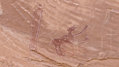 |
| Not sure what's going with this creature. |
 |
| Looking back down the canyon from the pictograph perch. |
 |
| I'm sure there's an interesting story here. |
We were cruising along on the sandy road, only got passed by a handful of OHV users. I thought we'd encounter more. Then, seemingly out of the blue, Scott starts climbing a rocky hillside. This is the way. Good thing he had a track loaded because calling it a footpath is mighty generous, yet there was some semblance of a path.
 |
| Follow the path!! ??? |
 |
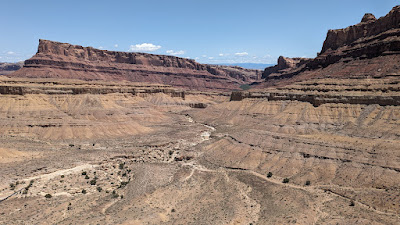
| This is an interesting shot. The flat area in the upper left below the mesa is I-70. The dirt road we started hiking on meanders in the center distance. Meanwhile, we gained a layer of geology. |
 |
| See? There really is a path!! And another layer to gain. |
 |
| Proper trail hiking!! Photo by Scott. |
 |
| Steep up to gain the ridge. Photo by Scott. |
 |
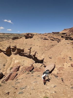
| Time to find a way down. |
 |
| The wash below is our target. |
 |
| Check your fear of heights at the door. Photo by Scott. |
 |
| We found an occasional cairn helping with route finding. |
 |
| Yep, it was steep and loose. |
 |
| It was still hard to believe we were hiking through this terrain in search of a river. |
 |
| Down in the wash, the hiking mellowed out. |
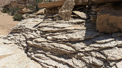 |
| Rock flow frozen in time. |
 |
| Flat, slickrock area of the wash. |
 |
| Caught this cool collared lizard posing. |
 |
| This appeared to be a recent collapse. The gray-ish color of the rock surprised us. |
 |
| Scott proclaimed we were only half a mile from the river. We were all ready to get in and float the afternoon away. |
 |
| We found some shade in the Tamarisk to inflate the boats. |
Hard to believe, but this was going to be my first time in a boat on a river. Scott gave Lindsay and I, she had been on a few trips before, so not a complete noob like me, a few tips on anticipating the turns and generally just try to keep the boat down the middle. And don't worry too much about getting too close to the sides, it'll happen.
Of course one of the tricky things to do is getting in/out of the boat. The launch was fairly anti-climatic, which was a good thing. I was in!!
 |
| Lindsay gets in and takes off down probably the swiftest section of the entire day. Might as well start with a bang, eh? Photo by Scott. |
 |
| It almost looks like I know what I'm doing. Photo by Scott. |
 |
| It took a while before I felt comfortable getting my phone out for a pic. For some reason, my settings got switched and I ended up with this warp speed effect, which turned out kinda cool. I fiddled with the phone for a moment in the sun to get my settings back to normal. |
 |
| Already worth the price of admission. Yowza!! Photo by Scott. |
 |
| Oars up!! Taking a moment to just float and soak it all in. Photo by Scott. |
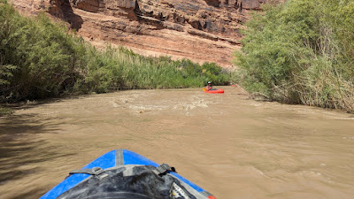 |
| Aside from the entry, this was the only other section that sped up. Fun!! |
 |
| Interesting pyramid markings on the cliffs. |
 |
| Towering cliffs, good sense of scale to my dot on the water. Photo by Scott. |


No comments:
Post a Comment