Evan and I zoomed down the last stretch of fast pavement on Schnebly Hill Rd to the junction of Hwy179 thereby completing our 4 day, 252 mile route. No one was there, only a dark bridge carrying cars over Oak Creek, but that didn't matter - we did it! The next stop was directly across the street:
Oak Creek Brewery!! Time for a celebratory brew and some much needed grub.
Day 1: Sedona to Mingus Mountain
This all started Friday morning out of the Basha's parking lot in west Sedona. We opted to change the start location for this stage race format from Flagstaff to Sedona. A weather system moved into the area Thursday afternoon and the high probability of encountering 'death mud' up on the
Arizona Trail (AZT) south of Flagstaff brought back awful memories from my
AZT300 attempt in April. A few posts were made, people contacted, and the switch was made.
We met up at the NY Bagel shop around 6:30am on Friday to a steady rain. I had just driven through a massive downpour in Oak Creek, so bad that I couldn't see Bell Rock as I drove right next to it!! We all decided to wait it out for a bit since the storm was about to move along. We were 5 strong to start: myself, Evan (from San Diego), Steve (from Tempe), Tom (from Boulder, CO) and Kip (from Dallas, TX). We readied ourselves at the Basha's and finally got rolling around 9am.
 |
| Ready to roll out! |
 |
| Kip & Tom. |
 |
| Steve. |
 |
| Evan. |
We started off with a few miles of fast pavement riding to the Morgan Rd turnoff, after a quick jaunt through a neighborhood we were onto the red dirt of Sedona and the Broken Arrow Trail. Although my legs were fresh and ready to go, I could tell I'd have to pace myself over the route to account for all the extra weight. I wish I would have had a scale at the start, my best guess is that my loaded bike weighed in at 50+ lbs & my pack around 18lbs.
 |
| The first trail of the route. |
We picked our way up Broken Arrow, generally staying together at this point. The trail had a few spots of mud, nothing crazy, but enough for my chain to get dirty. I pointed out a rock feature to Kip as I walked down a steep decline, that would be the last time I saw him. He decided to pull the plug after less than a mile of trail due to the technical conditions. We found out later that he'd been doing 60 mile gravel road rides near Dallas in preparation, but the trails out here definitely test your bike handling skills, couple that with the elevation and cumulative gain and it's no wonder he felt the way he did. Too bad, he seemed like a real cool dude. I only wish he would have stuck it out through Red Rock State Park at the least, giving him a nice loop through Sedona & still an easy bailout to the cars.
While we wondered what happened to Kip, Tom kept going and we wouldn't see him again until camp. The top of Broken Arrow is Chicken Point, a fantastic overlook of Sedona. We started down from the overlook and Steve pulled away from Evan and I, we wouldn't see him again until the next morning. Evan and I have very similar riding skills & fitness so we ended up riding most of the route together. We cruised through Sedona on the Templeton & Baldwin trails, both new to me which was nice. We paid our $3 to transverse through Red Rock State Park, stopping to clean off & re-lube my chain, and begin our journey over towards Cottonwood on the Lime Kiln Trail.
 |
| It sprinkled on & off, but the mud was minimal. Photo by Evan (EV henceforth) |
 |
| No matter the conditions Sedona is always a good photo. |
 |
| Evan riding some ledges along the Templeton Trail. |
 |
| I'm pretty sure I rode down that. EV |
 |
| Skies are clearing. EV |
We heard some mixed reviews of Lime Kiln trail, but not a whole lot of information is out there. It's a seldom used trail with a mix of singletrack & jeep roads. My buddy,
Ray, completed this ride the week before & was able to share a ton of route knowledge, so we knew there was a short HAB up the first ridgeline. We were expecting some boring sandy sections, but the storm actually made this trail very enjoyable.
 |
| The first ridgeline of Lime Kiln. EV |
 |
| Fantastic views of Sedona, we came from the red rocks in the distant left. |
 |
| Yes, it was dry. |
 |
| Evan rode farther than I, but we still HAB'd it to the top. |
 |
| Sure glad we didn't start in Flagstaff today!! EV |
 |
| The tall grass made for a sweet riding scene as we neared Cottonwood, Mingus Mtn looming. |
 |
| I love this shot, a synopsis of the route: stunning beauty & incredible singletrack on one hand and a dark sinister side full of postholes, softball sized rocks & steep unrelenting HAB on the other!! |
 |
| Closing a gate never looked so good. |
 |
| The sandy dirt compacted quite nice after the rains moved through. EV |
 |
| The last couple of miles down into Cottonwood were a hoot! EV |
Upon arriving in Cottonwood we had 2 goals: eat some lunch & then supply up for the long route up Mingus Mountain & over to Williams the next day. Total mileage is just over 70 miles with a ton of elevation gain & only one water source (Verde River) that we were planning on utilizing. We made our food stop at
Hog Wild BBQ & that was delicious!!
 |
| We are HERE. Mingus Mtn is the next rise, to our campsite. The following day we'd ride down to the Verde River then all the way up & over the next peak (Bill WIlliams Mtn.) into Williams, AZ. EV |
We stocked up for the next day at the Maverick gas station as the last rays of light illuminated the sky. Evan and I started our grind up Mingus, first on paved road, then dirt. Slowly we moved and gradually the pitch became more & more intense. We came to point on the cue sheet that asks 'Steep enough for ya?' Yes, Scott, plenty steep, let the HAB'ing commence. Hike-a-bike does have its benefits, you use different muscles and get off the seat for a while. The downside to me is that it is very slow and long stretches of HAB really drain me out. We alternated the HAB'ing with riding when the pitch subsided briefly. As darkness settled in, we climbed & climbed, then we finally caught a glimpse of just how far up the mountain we've come. Looking down into Cottonwood was quite a sight, almost like a view out of an airplane. Every now and then we would catch sight of a wandering headlight high above us, Steve?? We found out later it was, and Tom was spying on Steve as he climbed the mountain!!
 |
| Last rays of light over Mingus Mtn. |
We finally hit singletrack, rode for a short bit then began the HAB process once again. At one point the trail turns sharply upward into an S-curve requiring a full lift of the bike, all 50+ lbs of it, up some rocks all while you carefully place your feet and climb up to it. This 'human ratcheting' as its been called gets repeated a few times before topping out onto
less-steep trail. I was very glad to be past that section and we began ticking off the final tenths of a mile over countless switchbacks to the top.
 |
| One of the sketchier sections for footing near the top. |
By now the temps had dropped to the low 30's, my hands were getting cold under my two pair of gloves and the wind had picked up considerably. We
must be near the top!! Cottonwood was a distant glow of lights below us and at 11:06pm we finally hit the timing stop point for the stage. We started to ride the flat boulder strewn singletrack at the top, but I kept bouncing off the rocks and decided it would be best to just walk it out to the forest road (FR). All that remained was a quick jaunt down a FR to the camping spot for the stage, but there was one turn to negotiate.
I was fixated on the GPS track so we wouldn't blow by the turn when Evan yelled out that something large just ran across the road and was staring at us from the woods. 'It's just an elk or deer' I said as we motored on. Evan's reply, 'that thing had a big tail!!' Oh. Hmmm, must have been a mountain lion and just our luck we were less than 1 mile from camp. Sweet dreams.
At camp we found Tom still awake, but no sign of Steve. I had to stand around for a bit until I could regain feeling in my fingers from the cold ride down the FR. We heated up a warm meal, sorry Ray, but I was very glad to have my stove!! Cracked open a cold one that I lugged up from Cottonwood and set up my tent. This turned out to be a comedy of errors. First mistake, when entering a 1-man tent be sure to enter in the direction you plan to be in. Inside the tent, facing the wrong way, I tried to maneuver myself so I could get into my sleeping bag, but my hamstrings wanted to cramp!! Doh! After about 5 minutes of squirming around, I accidentally knocked my one pole support down. At least I was facing the right direction! I couldn't get the pole to stand back up & I wasn't about to get out of the tent to do it. So, I climbed into my sleeping bag with the roof of my tent just above my nose - how comfy. This only became an issue during the middle of the night when I moved, hitting the tent, causing the built up condensation to rain down on my face and arms!!! Holy crap was that COLD!! My other issue was exiting the tent in a timely fashion, better not wait until an emergency, because I couldn't tell where the zippers were!! I ended up not having any issues, but did continue to sleep without the support of the pole. I actually felt pretty well rested the next morning believe it or not.
Day 2: Mingus Mountain to Williams
We began stirring just before sunrise, heard some noise coming from behind a row of bushes and found Steve had camped about 100 ft before our campsite.
 |
| Mingus Mountain campsite. |
Tom took off fairly early, he was much better at the early morning starts than Evan and I. We packed up, grabbed a bit to eat and headed off down the backside of Mingus around 8:30am. Rounding the mountain opened up one of the more expansive views of the route, a sprawling Prescott Valley below us. Ripping down Little Yaeger trail was a blast, except for me having to stop a few times to re-adjust my sleeping bag. Every now and again it would slightly rub the front tire when the forks would compress.
 |
| Fast descent through the forest. EV |
 |
| Prescott Valley |
 |
| Steve on Little Yaeger. EV |
Just before crossing Hwy 89a it was time to shed some layers. It was a beautiful day, cool, crisp, clean air as far as one could see. Next was a series of jeep roads leading down (mostly) to the Verde River roughly 30 miles into our 68 mile day. One stretch of jeep road under the powerlines was rumored to be littered with goat heads, not today!! My guess is the storm blew them all off the road!!
 |
| Goat head free riding!! EV |
 |
| We were being watched. EV |
 |
| Easy miles. EV |
 |
| Must've been a popular target. EV |
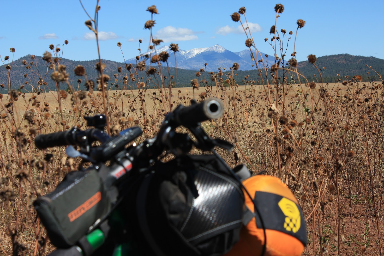
 |
| Our first view of Humphrey's Peak!! First snow of the season to boot. |
 |
| Flyin' down Perkinsville Rd made it difficult to keep your eyes on the road. EV |
 |
| It's all uphill from here!! Crossing the Verde River. |
Steve descended Perkinsville Rd like a man possessed, he was below the bridge on the right when I passed. I shouted down to him that Ray had suggested a spot about 100 yds to the left for easy access to the river.
I made my way over to the riverbank and fiddled with the Steripen coarse filter setup, that was a chore putting it together!! After scooping out 1 liter of river water the bottle was ready for a blast of UV. On top of the riverbank I heard a man yell down to me, 'are you filtering water?' I confirmed and he insisted that I get my water supply from him, since he had 15 gallons or so for his family that afternoon. Back to the river my 1 liter bottle went and I gladly filled up with fresh water. Next, I was offered a chorizo and bean burrito on homemade tortillas!! Duh, of course I'll take one!! They proceeded to offer me a seat, a soda and a second burrito from freshly deep-fried chicken!! Trail angels for sure. I had to pass on the second burrito, I was feeling a bit bloated and knew eating more would not go well on the upcoming 5,000' climb towards Williams. The family let me dump my trash from my pack, I paid my utmost gratitude for the food & drink then made my way over to the bridge.
 |
| Thanks to their kindness, I was fueled & ready to go. |
 |
| Thanks for the tip on the water spot Ray!! |
I met back up with Evan and Steve, but they had already filtered water from the river and had a bite to eat. Bummer. I was ready to go, so I took off up the road knowing they would catch me pretty quickly. Steve caught up with me and we rode together for a while, but the next thing I knew I was by myself. Still feeling energized from the burrito & cola I pedaled on, climbing away from the Verde on a nice stretch of forest road. The route finally peeled off to the right on a more primitive jeep road, staying left was a more direct route into Williams.
As I found out later, both Evan and Steve made this wrong turn costing them 6 miles. Steve was running low on water, so he decided to keep going into Williams playing it safe and securing a room for the night.
 |
| A short HAB section on the jeep road was a welcomed change of pace. |
 |
| Climbing past an old mining operation, Mingus Mtn in the background getting smaller. |
I only took one short snack break on my way up to the pines. By the time I knocked out a few miles in the trees it was getting late and the temps were dropping, time to layer up. While I was getting my arm warmers on & snapping a few pics, Evan came by and told me about the wrong turn. We still had some fast miles before hitting Bill Williams Mtn, but like day 1, this day would finish well after dark.
 |
| Back in the pines, just in time for the golden hour. |
We made it to the turnoff for the Benham trail around 8pm. We were only 3 miles or so outside of Williams via paved road and let me tell you, it was very tempting to cruise into town for a meal & brew! Instead, we turned left and started up Bill Williams Mtn.
 |
| Trail #38, 4 1/2 miles to the top, huh. Turns out we only needed about 3.8 to the downhill. EV |
The trail started out nice enough, but soon it kicked up in grade and my tired legs were once again walking beside my rig pushing it uphill. Thankfully, the trail mellowed again and I was able to ride for quite some time, then things got steep. I began ticking down the tenths of miles as the HAB wore on switchback after switchback. Evan caught up to me and left me in the dust, I was really feelin' it and my mind began to wander into thoughts of pizza, burgers, brews, a hot shower and comfortable bed! Then all of a sudden it went
DARK, real dark. For some odd reason I decided to run my headlight on high for the ascent, not a wise choice as my battery was now dead. Fortunately, I brought both batteries for my MagicShine light. Now, in the pitch black I had to swap out the battery that was fixed onto my helmet. I dug through my pack & found my led push light to show me the way. I swapped out the battery & resumed my drudging up the mountain.
I'm sure this trail can be fun to ride on a bike not loaded down with bikepacking gear, but on this night, I had no intentions of trying to pedal much of anything. The few spots where the trail crosses the dirt road are agonizingly steep and loose. At one of the crossings a 4x4 loaded with youngin's stopped and asked me if I was enjoying my 'hike', 'yes' was the answer and I kept moving.
We finally topped out just shy of 4 miles into the trail and I was more than ready for some downhill & this day to be over. Ray had warned me about the stairstep-like drops near the bottom, so let's have some fun getting there! Right away I knew getting there would be a bit more daunting than I had hoped, the trail was fairly steep & the turns were awkwardly setup. An approach to a sharp turn would lead you off the trail into a drainage. The turn had to be negotiated by getting the front wheel over a 90º rock water bar before continuing on. Strange. After the first few I began to get accustomed to the goofy turns. I was cruising on a stretch between turns when out of nowhere I crossed up my bars BMX style and faceplanted hard!! What the....seems I clipped a rather large boulder with my front tire - never saw the darn thing!! A quick body/bike check revealed no damage, only my pschye. Once again, I decided to play it safe and began to HAB
down Bill Williams Mtn. There were too many iffy spots that I just didn't feel good about, the sleep monster was creeping in as it was now after 11pm. I walked for a while, then the trail mellowed and I began riding once more.
I caught up to Evan when he stopped to let a skunk have the right-of-way on the trail. We tried to shoo it off the route but the skunk wanted to lead us down the mountain for a bit. It added a bit of humor to our evening of suffering. We made it to the stairstep section, walking most of it, then finally hit the last bit of trail leading into town. That section was fun, but seemed to go on forever. We finally dumped out onto the streets of Williams to stop our stage timer at 12:10am!! Now what's still open??? Pizza? Closed. Mexican? Closed. Ah yes, good 'ol reliable, Circle K!! We grabbed some food for the night & next morning, sent Steve a text to find out what room he was in, took a much needed shower and finally hit the sack near 2am.
Completing this stage, in my opinion, put the toughest part of the route behind us. I was totally cooked, but knew I could complete the route. Nothing left could compare to our struggles up Mingus & Bill Williams Mtns, right?
Day 3: Williams to Flagstaff
The
next morning was cool & crisp, not cold, but that was more likely due to us rolling out around 9am instead of 6am. Williams is a cool little town right on historic Route 66, probably more known these days for the Grand Canyon Railroad.
 |
| Deluxe travel options galore in Williams. |
This was going to be another long day, but had a ton of fast miles, it was nice to have a good 12 mile or so warmup leading to Sycamore Canyon.
 |
| Warming up on our way to Sycamore Canyon, we'd be on Humphrey's Peak in the distance near day's end. EV |
I've heard people refer to the canyon as Sick-of-more, but I rather enjoyed it. Sure, there is a bit of HAB at the ends of the canyon, but they're short. In between is roughly 5 miles of flowy singletrack with the occasional tech move tossed in, right next to the rim of the canyon. How terrible could it be?
 |
| I'd like to return to check out some of the other trails in the area. |
 |
| The rim trail had some tight spots for my 29" clown wheels. EV |
 |
| This must be an incredible spot when the water is flowing, not too shabby dry either. EV |
 |
| One of the faster sections. EV |
 |
| Evan taking it in. |
 |
| Snack break at the end of the canyon. |
We dumped out onto some double track, then graduated to a nicely graded FR for the next dozen or so miles. We were heading towards I-40 and the one re-supply spot, Texaco, for lunch and more goodies.
 |
| This is big sky country, AZ style. EV |
 |
| The change of seasons was all encompassing. |
 |
| Bigfoot crossing?? |
The general store at the Texaco was a welcomed break, it was about 30 miles into the day, just shy of the halfway point. We grabbed some lunch and kicked back on the benches outside while observing the locals milling about. Mill about they did. We had a lady bend over near the gas pumps to display her 'whale-tail' tattoo to us, chatted up the guy behind the counter for a bit and watched some old dude park across 3 spaces in front of the store, climb out of his truck wearing no shirt only suspenders while his hoarse lap dog tried to escape out a side window. The old fella came out of the store, stopped by our bikes, mumbled something to us...a few times, we couldn't comprehend, then proceed to climb back into his truck, lifting the door so it would close properly before driving off. Show's over, time to start pedaling again.
 |
| Humphrey's Peak is getting closer! EV |
 |
| The cows were reluctant to move, we were on their turf. EV |
 |
| Saw a bunch of tarantulas on route. |
At some point during the miles of forest road saddle soreness started becoming more of a discomfort. The shifting game began, find a comfortable position & ride it out as long as I could, then stand and mash the pedals for a bit re-adjust repeat. This would continue until the finish back in Sedona, only the duration of seated pedaling would shorten considerably.
We were now on the lower flanks of Wing Mtn. getting oh so close to the final climb of the day up FR151 towards the über fun downhill on the
Arizona Trail (AZT). My GPS decided to cycle power for no apparent reason, I stopped & reset it, resuming the course and moved on. Didn't think too much about it, my GoMadic external charger had been powering it most of the ride without issue. The track was loaded, timer ticking away with the miles. Up Wing Mtn. we went.
We crested the mountain after a short but steep HAB, then it was on to the Wing Mtn. Moto trails. Moto trails can be a real mixed bag of tricks sometimes. This section of trail happened to be really good. There were just enough whoop-de-doos to keep it fun, but not make you nauseous. Throw in some G-force banked turns and a little bit of climbing and this was getting real fun!!
 |
| On the Wing Mtn. moto trails. EV |
 |
| Couldn't pass on this photo op. EV |
 |
| We caught up with Steve when he detoured for lunch, then he returned the favor as we closed in on Humphrey's Peak. |
The golden hour was fast approaching, we all wanted to make the AZT turnoff before sunset or at least before the need for lights. We soon started up FR151 and I settled in to the climb as both Evan & Steve left me in the dust. I think we encountered the most traffic of the route on this stretch of dirt road. Hunters galore, Autumn color gawkers and people returning from day hikes, whatever the reason they were out in force. One more turnoff onto FR9215B for the last mile up to the AZT in the waning daylight.
 |
| FR151 climb. |
 |
| Heading up FR9215B at dusk. EV |
 |
| Junction of FR9215B & the AZT, time to turn on the lights & rip! EV |
We made it to the AZT as the last glimmer of light sank on the horizon. I was now on familiar ground, I've ridden this stretch of AZT a few times the past couple of months, most recently on a tuneup ride,
Flagstaff CrAzY 90. This is one of the best sections of AZT in the state, now I get to ride it at night!! What a blast, I was getting a kick from watching Steve & Evan's lights dance ahead of me through the forest as we descended some 2000'. Near the bottom the trail crosses Snowbowl Rd. then skirts across the mountain on fun XC singletrack. More downhill was had in the Fort Valley trails leading over to Shultz Creek, what a great finish to another long day in the saddle.
We had one more connector trail that sliced through a forested neighborhood. Evan and I were cruising along when BAM! I crossed up my bars
again BMX style and took a hard digger into the trail. Once again I failed to pick up a rather large rock in my lightbeam and squared it up with my front tire. Drat. All body parts checked out, bike was ok, let's get to the stage stop already - I'm cooked.
We finished the day at 8:37pm, finally a day under 12 hours!! My GPS started getting all wonky, constantly cycling power over and over. I just figured the batteries were getting old or too cold so I turned it off. We jumped on the paved urban path and met back up with Steve then decided to split a hotel room once again. All checked in, it was time to walk over to
Beaver St. Brewery for a delicious Oatmeal Stout & burger, how devine.
 |
| 3 adults & 3 bikepacking rigs in a very small room, Evan was nice enough to sleep under the table next to the TV!! |
Day 4: Flagstaff to Sedona
I slept really well, it's amazing what total exhaustion does to you. We got up & moving fairly early, making our way over to '
The Place', the
official start of the stage race. Steve took right to the trail, so we wished him well and turned our focus towards a hearty breakfast. We found a bikepacking rig leaning against the wall as we entered, it was Tom, who we hadn't seen since camp on Mingus Mtn. We chatted with him for a bit, then he too took to the trail. By the time we finished breakfast & made our gas station re-supply it was near 9am. So much for an early start, but what else was new?
We soon dropped down onto the
Flagstaff Urban Trail System (FUTS) and it almost has an underground feel to it. It's a wide gravel path following a drainage through the city, but you feel like civilization is miles away. Flagstaff has a really cool thing going on there.
 |
| Rolling along the FUTS. EV |
I started thinking early on about how stoked I was to be finishing this incredible route today, it was going to be a shorter mileage day, no real big climbs, fast singletrack and a huge 6 mile descent into Sedona!! The initial miles were on rolling forest roads, then some rippin' singletrack near Fisher Point.
 |
| We took a slight photo op detour so Evan could see Fisher Point. |
 |
| Ride the AZT via bonfire!! EV |
 |
| I love this spot, but soon we'd begin the climb to Anderson Mesa. EV |
We started the climb up towards Anderson Mesa, I wasn't really looking forward to this section of trail. Reports were that, while flat, the trail is very bumpy for a few miles. This section was the main reason we decided to start in Sedona as the ground on the mesa is clay-based, absolute killer for a drivetrain when wet, read: sticky death mud!!. We hit the one moderately steep hardscrabble HAB up to the top, then hit some of the mildly bumpy singletrack leading to Marshall Lake.
 |
| Near the start of Anderson Mesa. |
 |
| Mid-morning snack. |
 |
| Marshall Lake TH. EV |
Past Marshall Lake the 'fun' really began. The trail was post-holed by free ranging cattle, most of it looked to be recent, into the soft storm soaked Earth. Now imagine someone walking on this trail with a giant sack filled with baseball/softball sized rocks littering the route. Perhaps this section is easier on Day 1 like intended, but at mile 210 or so, it was seriously kicking my butt in more ways than one!! Ouch. One of the few bright spots was the overlook of Lake Mary and the shrinking views of Humphrey's Peak when we looked back over our shoulder, truly a sight to behold.
 |
| A rare smooth'er' section of trail. EV |
 |
| Cool view of Lake Mary. EV |
 |
| Humphrey's Peak in the rear view mirror. |
 |
| It's 'only' 6 miles or so of this. |
One of the more frustrating aspects of this section for me was my inability to go faster. I was plodding along barely keeping a 6 mph average! At one point I had to stop, toss the bike aside, giving my wrists/hands/butt a break from all the jostling. I was ready to be done with soul sucking Anderson Mesa!! Bleh.
 |
| Finally dumping out onto a less bumpy jeep road. Good riddance Anderson Mesa, you're #1. EV |
A total of 10 miles put Anderson Mesa and the rocky jeep road behind us, we were thankfully back on sweet forested singletrack! Shortly after crossing Lake Mary Rd. the batteries in my GoMadic charger finally konked out, it took me a while and a ton of digging, but I located my spare set of AA lithiums that I mistakenly bought for the SPOT (takes AAA). Now with renewed power, at least in my Garmin, we started the 8 mile or so gradual ascent along a long forgotton railroad grade.
 |
| 8" diameter trees now grow on the old railroad bed in spots, the forest is reclaiming what was hers. |
 |
| The remnants of an old railroad bed and a good place for a snack break. |
Eventually we met up with the Mormon Mtn trail, it was rather short, but it was GOOD. A few short climbs, followed by some fast twisting singletrack! This is what we were waiting for all day. We were dumped onto a forest road, knocked out a short climb then we began to descend and descend we did. The extra weight of my bike had me flyin' down this road so fast it was borderline frightening. I had to keep brake checking to maintain a sense of control. If this were a nighttime descent you could have seen my brake pads glowing, I'm sure of it.
We were finally ticking off fast miles, but we had one more turnoff near Munds Park, for one final short climb up a secondary forest road. We were really hustling now, trying to make the Sedona overlook & hopefully some of the final descent before darkness settled in. While we were making good time on the forest road, Evan gapped me on a short ciimb & he was gone. All of a sudden the turnoff appeared on my GPS, no Evan. I was ready for one last snack before the final push, so I kicked back for a few minutes in hopes that he just blew by the turn, found his error & would return. Evan had been doing the whole route solely by the cue sheets and when we were together, my GPS. I was just about ready to move on when he rolled up. He only went about a 1/2 mile past the turn before figuring it out.
 |
| One final snack before heading up the last climb. |
I think we were both ready for the ride to be done at this point. I really wanted this climb to be over quickly and luckily it was. The top was rough, rocky, rutted, even muddy in spots, but then it opened up and more downhill insanity ensued. Next thing I knew there was a sign 'I-17 1/2 mile', cool. We were now on Schnebly Hill Rd, our last forest road to the overlook!! The sun was getting low on the horizon and just our luck it was setting directly in eye's view of the road. It was a blinding downhill and we only saw a couple of vehicles thankfully. Schnebly held a few tricks up her sleeve, two hiccups in the downhill slowed our pace as the sun dipped lower. A few minutes before the sun set we reached the popular overlook area, finish line in sight!!
 |
| Sun setting behind Mingus Mtn. |
 |
| I was a little bummed we missed this as our Day 1 camping spot with the staggered start. |
I wasn't watching my GPS closely enough & led us down Schnebly a little bit before realizing we needed to backtrack from the overlook UP to the Hot Loop which then leads us to the official camping spot for Stage 1. We took the 50 yard detour to check it out, what a spot, must've been great for the group on Oct. 5th to wake up in this location. Next year.
We accepted the fact that we'd be finishing yet another day in the dark. I was a bit concerned about my light battery. I had been using my second battery for a lot of the night riding, but it was still showing 50% power. We readied for the descent down the Munds Wagon trail and took off.
 |
| Sedona from the top of Munds Wagon trail. EV |
I have to be honest here, I wasn't looking forward to doing this descent in the dark. First time on this trail, the elevation profile made it look stoopid steep, I had heard it was rocky/loose in sections - my favorite, and I was just exhausted after 4 days of hard riding. I kept waiting for the trail to get really steep, it never did. There were a few spots where I could tell by the darkness to my left there was a substantial dropoff, just focus, keep riding. Soon after starting down I was regretting putting my jacket on, it was getting toasty as we lost elevation. I didn't want to stop to take it off either. Four miles or so down the trail it seemed to bottom out.
 |
| Fun slickrock areas. EV |
We rode a series of drainage crossings and then it happened. We rode out into a trailhead onto the bottom paved section of Schnebly Hill Rd & one more final super fast descent to the Oak Creek bridge, the junction with hwy 179 thus completing our ride!! Woohoo!! We did it!! No one was there to greet us, no ribbons, no PA announcer, but there was beer across the street!!
Oak Creek Brewery here we come.
 |
| Evan all smiles, great riding with you!! Well done!! |
 |
| Somewhere in there I'm exhilarated. EV |
We had planned to ride back to the cars about 2 miles up the road before getting some grub, but they were about to have their last seating of the evening, so in we went, funk and all. I had a mighty fine tasting nut brown ale, well deserved if I do say so myself.
A few other notes from the event.
- I was on & off my bike so many times I perfected the 'Viscacha dismount', even the Russian judge gave me high scores!!
- Thanks to Chad and Scott for putting together such an incredibly challenging yet rewarding course, this really is the crown jewel of the Arizona Endurance Series.
- Ray, thanks for all your trail intel from the week prior, I used almost all of your advice - except the part about starting early everyday!!
- Definitely a huge thanks to my wife, for putting up with my silly riding obsession. Your support means everything to me!!
- As of this writing, it appears my light battery that konked out on me during the Bill Williams HAB actually is dead. Time for a replacement.
- It's now been 11 days since finishing, I almost have all my feeling back in my toes. They didn't bother me during the ride, but starting the day after the ride my toes had a slight numbness / tingly sensation. I've since adjusted my cleats on my shoes to change the pressure points on my feet.
- No mechanicals, only a dirty chain from the bit of mud early on in Sedona.
- Gear worked great, just need to fine tune & lock down my sleeping bag position. Slight gear casualty, my compression sack has a small tear in it most likely from one of the two crashes.
- My Garmin Edge 705 that was cycling power near Wing Mtn ended up having a file glitch. The stats were all recorded, appear to be correct, but the track straight-lined from the spot where the power cycled to the next spot riding into Flagstaff. Weird.
Final stats:
252.31 miles
22,446 feet of elevation gained
Official time: 52:37 (hh:mm) good for the lantern rouge!!
Thanks for reading & checking out the blog. Until 2013, ride long, ride strong.
 |
| AES - Coconino 250 Stage Race route. |
Here's a link to the
full set of pics: