That's a lot of acronyms to a blog title, no? AES APC ITT =
Arizona Endurance Series - Antelope Peak Challenge Individual Time Trial for those scoring at home. To be fair, I wasn't racing the course or riding solo, Shannon &
Eszter let me tag along with them for a rerun of the official event a week earlier. All three of us had reasons for missing out: bee sting, sickness & dog sitting. However, we all wanted to do the route. I did have one small goal on the day: complete the full route before sunset!! In my previous two rides on the APC I wasn't really close.
 |
| The famous arch that greets riders prior to the 24 hour in the Old Pueblo race. |
 |
| Our staging area near the arch. Mt. Lemmon towers nearby. |
 |
| Junebug singletrack, part of the 24HitOP course. |
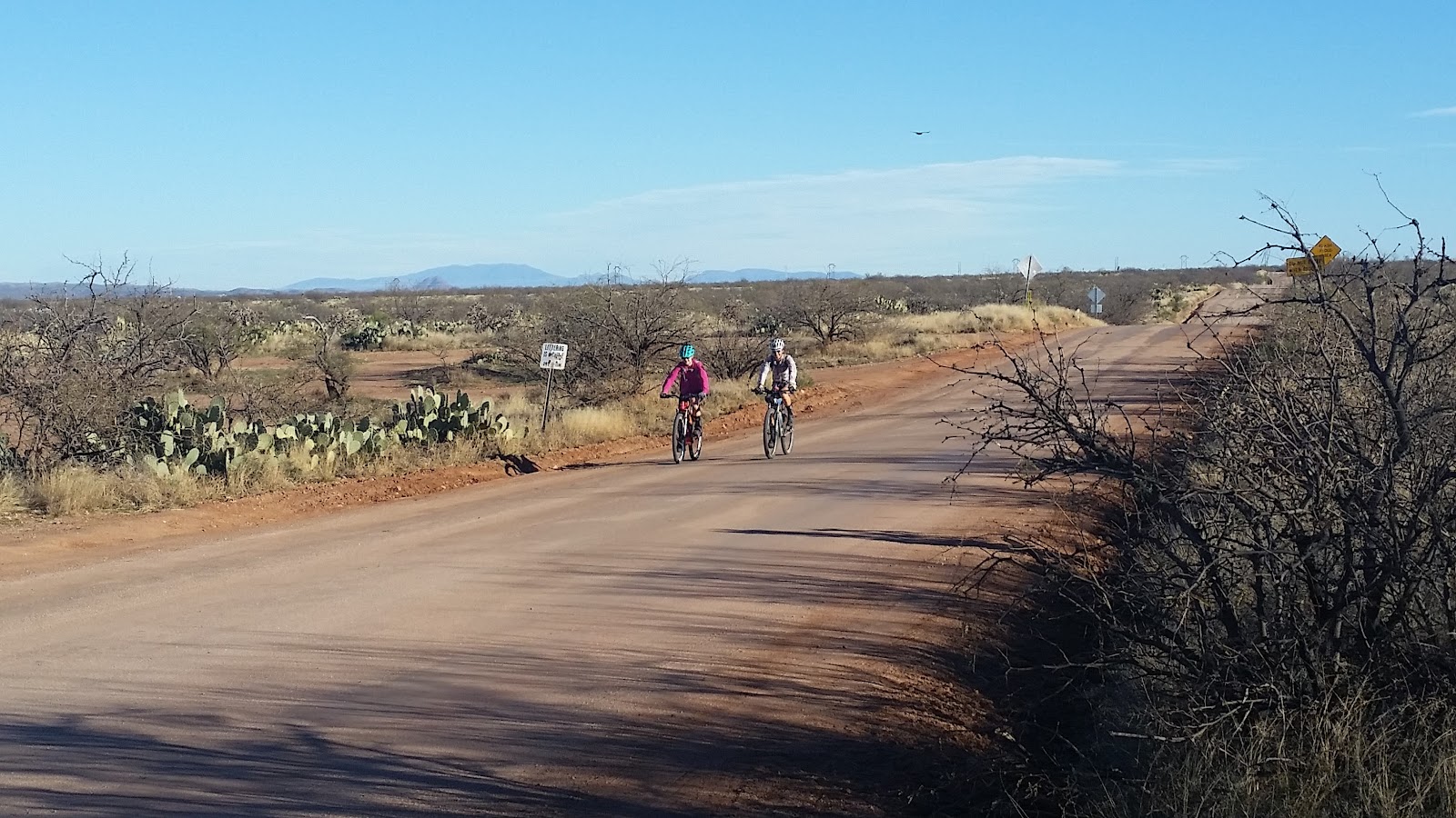
The three of us met up just before 8a for a cool warmup on Willow Springs rd & the paved AZ77 into Oracle. I'm sure we gathered a few odd looks from the 24hr crowd as we pedaled away from the course. This was one of the last weekends for riders to pre-ride the route.
 |
| Shannon & EZ on Willow Springs rd. |
The paved spin up the seemingly infinite horizon climb on AZ77 is a bit of a drag. At least it goes by relatively quickly when chattering about things like 'Why are so many people going to Biosphere2 this morning?' Where's Biosphere1? (hehe). Sixteen miles into our day we arrived at one of the iconic trailhead views along the entire length of the
Arizona Trail: Tiger Mine TH.
 |
| 3 bikes, 1 rad trail. |
As soon as we dropped onto the trail I began having
flashbacks to the Gila100 from last January. What a strange series of events that ride turned out to be. We made fairly quick work of the five drainages we had to traverse. Chatted with a father & son out segment hiking the AZT on an overnighter. So cool to see more folks out enjoying this great trail.
 |
| Antelope Peak way off in the distance. We'll ride around that later. |
 |
| One of the many ups & downs. |
 |
| Putting some distance on Mt. Lemmon. This gate marks the end of the drainages. |
It was time to shed my jacket as things began to warm up. We all commented how much better the trail seemed to ride so far. A bit less rubble to surf on perhaps? I was surprised how easy the initial climbs were, sure I walked a bit, but nothing compared to prior rides.
We merged onto the gasline bypass section and I was curious to note the visibility of the trail in daylight. Wow, what a difference. I found it hard to believe I missed so many turns during the Gila100 fiasco, but I guess that's what happens when you don't have a GPS and your lights are on low!!
 |
| Strange to see Saguaros singled out like this. |
 |
| It was that kind of day. Cheese!! |
 |
| Shannon was always easy to find, EZ camouflaged well. |
We zipped across a small dirt road following some tire tracks and the trail dead-ended into a tangle of branches & thorns. We took this opportunity for a quick snack and for me to shed another layer. I'm fairly certain I was being mocked for possibly overdressing when EZ asked if I had a prom dress in my pack!
It was about then when we noticed there were 4 other riders down the dirt road fixing a flat. Not the type of trail you expect to see others roaming about. They too missed the turn and soon the seven of us rolled north.
 |
| Traffic jam on the AZT!! |
We all joined up at the gate leading into the Bloodsucker wash descent. They were on an out-n-back day ride. A couple of them turned around as we pointed our bikes downhill. Two fellas joined us for a bit of the downhill before heading back towards Tiger Mine.
 |
| Shannon riding off the Biosphere. |
 |
| Some fun contouring lines here. |
 |
| This downhill is guaranteed to put a grin on your face. |
 |
| Took this one while riding, not bad. |
 |
| Is Antelope Peak getting ANY closer? |
 |
| The final turns down into Bloodsucker Wash. |
This downhill is one of those that makes your arms grow tired and your hands cramp from braking. A couple of punchy climbs are thrown in for good measure, but it's mostly down for about 6 miles.
We found our way across Bloodsucker Wash and began the jeep road climb out of the basin. A snack stop was agreed on, but the trail boss declared 'no 45 minute Schilling breaks!!' But, those are so fun!! I think we kept it around 10-15 minutes, then motored on up the road.
The jeep road section climbs fairly easily and we reached the next landmark, Beehive Well, quickly.
 |
| The girls cruising by a lone water source at Beehive Well. |
The sandy wash after the well was rideable, but I really wasn't looking forward to the next bit of trail. It's really steep, loose and off camber in bits. To my surprise the crappy section was really short. We kept gaining elevation and I was riding much more than I previously had. EZ was powering up everything out there, so impressive.
 |
| Postcard Saguaro. |
There were a few bits of HAB scattered about, but again the trail was riding much better than I remembered.
 |
| Antelope Peak is finally within our grasp. |
As the trail wraps around Antelope Peak it goes through a large cholla forest famously known for covering the trail in prickly chollaballs, yet, on this day the trail was clear of cacti!!
Our leisurely pace meant we'd have to skip a summit trek on the peak since we all didn't have lights. That was ok since the wind had picked up. We knew we had a stout headwind waiting for us at Freeman rd.
 |
| Freeman rd TH with a new shade structure. |
We grabbed a splash of water from the cache and turned west into the wind. It wasn't horrible, but you had to pedal a bit on the downhills to keep your momentum up.
A few miles later we turned back onto Willow Springs rd giving us a reprieve from the wind. The girls weren't too excited about riding the final section of the route through the Painter Boy trail. It's a notoriously vague route to begin with often leading to multiple scratches/cuts from catclaw. So, when we reached the split in the route I was on my own. Post-ride meal plans were hatched and they took off down the road as my route finding was getting underway.
I've been through this area a few times so I knew what to look for. Follow the 2-track into the wash, turn hard left and follow the wash until it reaches a barbed wire fence. Lift you bike over the fence, then find the missing strand of barbed wire to crawl through and hike back to your bike. Easy!
 |
| The beginning of the 'vague' area. |
This is where having a GPS track comes in really handy. Trust the track. I did and then stumbled onto some nice singletrack parting the tangled mess of branches. It was short lived, but did cover some ground. A few HAB sections through washes and I popped onto the 2-track marking the end of the vague area. To my surprise, not one scratch!! The area was completely free of catclaw. Whatever. I'll take it.
I kept my eyes peeled for the singletrack split and found it after initially overshooting it a bit. From here it's all singletrack, the primitive adventurous type, all the way to where it meets the 24hr course.
 |
| Not everything makes it out of Painter Boy. |
 |
| Love this type of trail. |
 |
| A second barbed wire fence, this one requires a crawl under. |
 |
| Golden Hour setting in. |
I ran into Igor, who rode the APC the previous week, who was out to explore the other trails off of Painter Boy. We were both racing daylight and kept our chat short.
I'm always surprised at how long Painter Boy is, the miles kept ticking by and I was getting a little anxious to reach the 24hour course. I knew when I got there, it would be a quick finish on a dirt superhighway.
I finally reached the junction and made the last short climb up to a saddle where all the racers enjoy a nice fast downhill into the exchange tent on race day. I arrived at the famed rock drop only to find a small 24hour town had already sprung up!! Plenty of people out pre-riding the course and making a weekend of it. It's a super fun event, one I'll probably do again, but with my bikepacking gear.
 |
| Top of the rock drop. |
 |
| In a couple of weeks this tree will become The Whiskey Tree. |
 |
| Last bit of singletrack on His & Her trail, note the sun is still shining! |
I rolled back into the staging area where Shannan & EZ were chilling. Ride goal accomplished, done right before sunset...by a minute or two!! We loaded up and found a great BBQ joint in Catalina, duly noted for next time.
As we departed
Bubb's BBQ my left hamstring decided it would be a good time to turn itself into a knot. Damn, that was painful. I stood there helpless by the dumpster for almost 10 minutes waiting for it to release. Luckily, I had no further trouble with it on the drive home.
I definitely prefer this route in the CCW direction with the start/finish at the Willow Springs arch. It's a great ride on some remote AZT that not too many people get to experience. Check it out if you get the chance.