I should have known when I arrived at Mike's place on Friday morning for our overnight excursion that things weren't going to go to plan. My first clue was my leaky hydration bladder that had deposited a rather large puddle of water on my passenger floor mat...soaking my left riding shoe. Dang it. Good news though, Mike had an extra Osprey bladder that I could easily transfer my Camelbak quick release hose to. Problem solved.
We hit the road sometime around 6:30a armed with a bag full of freshly made breakfast burritos, nothing was going to stop us now!! Our destination was Tusayan, the small gateway community a few miles outside of the Grand Canyon's South Rim entrance. A few weekends ago the annual AES Tusayan Tussle event was held, but I wasn't ready for it. Instead, Mike and I decided to bikepack the 100 mile route with the option to continue north on the Arizona Trail, AZT, all the way to the S. Kaibab trailhead, then return to Tusayan. This would put the full route near 109 miles. Weather was looking about perfect, maybe a few degrees warm, but not hot.
Our first stop would be to cache a couple gallons of water near the Moqui Stage Station, which we'd pass by twice on our ride.
Mike volunteered to drive, so we piled our gear into the minivan and headed north. We made a quick stop in Flagstaff so I could grab another burrito for dinner that night. Mike had found some directions to the water drop online, but it seemed like a fair amount of backtracking since we were coming from Flagstaff, so we consulted Google maps for a southern approach. The minivan doesn't exactly have a lot of clearance, but we figured if the dirt roads became too harsh, we'd turn around and follow the original directions as they stated the forest roads were well maintained. Our choice wasn't looking too bad, a few bumps here and there and some minor skid plate scrapes, but all was well. After a dozen or so miles we needed to make a right to link over to the road that would take us all the way north to the water drop. Our turnoff looked good and it was only a mile and a half long.
We approached a cattle grate with a gate, so I hopped out to open it. On the other side was the only small mud puddle we came across on the entire drive. It looked a little sketchy, but we were certain we could pass over the grate, then turn slightly left to stay out of the muck. I watched from the road as Mike navigated through the gate and made the turn. As he sped up the wheels slipped off the dirt shoulder and slid the van into the muck!! Mike almost had enough momentum to get through it, but alas, no. The minivan was stuck, spinning the tires about 3 feet from clearing the mess.
 |
| Mike moving mud. |
 |
| Not a lot of wiggle room upon entry. |
Mike tried to rock the van out to no avail, pushing didn't budge it either. We didn't want it to sink any further as it would high center. We looked around the landscape, not much out here. No rocks, just open prairie land with ant hills. There were a couple of fence posts lying around so we began moving as much of the muck away from the tires. It was tedious work, but we were making slow progress. I asked if he had anything to scoop the water & dirt and Mike emptied a Tupperware full of first-aid items into the back of the van. It did the trick getting a lot of the water out of the troughs. I then began scooping up as much ant hill dirt as I could, come to find out they were fire ants, nasty critters. They weren't too happy about having to rebuild their mounds but we needed the dirt. We tried jamming the fence posts under the tires to get some traction, but couldn't quite get them under enough, more tire spinning. We used the fenceposts to chip away at the center, giving the van more clearance and getting dry dirt under the wheels. After a while we removed enough muck to get down to a solid base. Mike began slowly trying to rock the van back & forth, with each move maybe gaining an inch or so. The van finally backed up about 6" and as he put it in drive I could tell momentum was building....go, Go, GO!!! The van broke free!! We were out of the muck after about an hour of mud slinging. One of those pesky fire ants happened to bite me on my right wrist during my last load of dirt, ouch! Didn't think too much of it as we were now able to continue on towards our water drop.
 |
| Doesn't look like much, but it almost derailed our weekend!! |
We were now on the final stretch of dirt road, which, by the way, was much more traveled!! A few miles down the road we began hearing a slight squealing sound. Hmmm. Then Mike looked in the rearview mirror, ahh, crap!! His bike had come loose from the rack and was leaning towards the back of the van. We hopped out, tightened it down, checked my bike and tightened it down a bit more as well. Whew! Good to go...once again.
It must've been a mile or two later as we were nearing the Moqui Stage Station water drop when all of a sudden...BOOM!!!! It sounded like a gunshot went off, startling both of us as we whipped around. The rear window of the van completely blew out!! There was shattered glass everywhere. We looked at each other and had to laugh, what next?? We figured when Mike's bike came loose on the rack, the handlebar ends must've been tapping on the window, scoring the glass. It didn't take much for just the right frequency to blow it to bits. A few minutes later we arrived at our water drop. All this excitement and we're still a ways from Tusayan and the START of our ride!!
 |
| Good air flow now. |
 |
| At least most of the glass fell on the floor of the van. |
The drive out to SR64 was much more pleasant than our drive in. In hindsight, it would have been much faster to come in & out this way even though it was more mileage. Our little water drop route ended up taking over 3 1/2 hours to cover the 38 dirt miles.
The innocuous fire ant bite began irritating me. The bugger got me on the underside of my right wrist, near my palm. There was now a 2x4" area oozing puss, swelling a little and itching!! Dang it. I took an antihistamine to help alleviate the discomfort.
By the time we arrived in Tusayan we were overdue for lunch. Not a whole lot to choose from on the quick here, so we opted for Wendi's drive thru. Two combo meals & Frosty's later, we were out $31. We ate lunch at our staging spot for the ride, a small trailhead off a forest service road near town. Since the van was now without a rear window, we backed into the space and hid what few items we were leaving behind. We didn't think anyone would mess with it, but you never know. While I was getting ready to ride, I noticed my arm stopping oozing and wasn't bugging me as much. Whew.
 |
| Clean that chain!! Photo by Mike. |
Some folks may think all these mishaps...errr, signs, would deter us from our ride. Nope. It simply meant a later start time. We rolled out at 2:30p after leaving Mike's place in Scottsdale around 6:30a!!
 |
| Finally, ready to roll out. |
 |
| Wild horses roaming about during the early miles. |
 |
| Our route started with lots of fast forest roads. Photo by Mike. |
 |
| We quickly left civilization behind getting into the thick of the Kaibab Nat'l Forest. |
 |
| Topping out on Skinner Ridge. |
 |
| A bunch of downhill fast miles began to stack up. |
 |
| Interesting wildlife water catchment. |
 |
| Harsh realities out here. |
 |
| We only encountered a few vehicles all day, helped keep the dust down. |
 |
| The shadows were growing long quickly. |
 |
| It was a warm afternoon with a very light breeze. |
 |
| You can see our water stash behind the bush beyond the sign. We both topped off for the roughly 40 mile loop back to this spot tomorrow. |
 |
| Moqui Stage Station pose. |
 |
Humphrey's Peak makes an appearance.
|
 |
| Lockwood Tank, no water needed. |
 |
| Somehow, I didn't see this Bull Snake as it was in the opposite side of the 2-track. Photo by Mike. |
 |
| While Mike was busy taking snake photos, I caught a couple of elk crossing the route. |
 |
| Look at that handsome fella!! Photo by Mike. |
 |
| Daylight waning as we neared the southern end of our loop. Photo by Mike. |
 |
| Our first glimpse of the new singletrack on Babbitt Ranch. |
 |
| We wrapped up the dirt road portion as darkness fell. |
It was still fairly early, sometime around 7:30 as we reached the new singletrack. We decided to ride back to the last road crossing of the trail in the picture above, then start looking for camp. A short distance beyond the road crossing we spotted a good sized flat open area. It was a little after 8p and set us up for a good nights sleep. In spite of the late start, we managed to knock out 46 miles. That left another 63 or so for the next day, which seemed a lot more doable.
 |
| Daybreak the following morning looks an awful lot like dusk from the previous night. Caught Mike capturing the moment too. |
We were stirring fairly early, but no rush to break camp. The night had been pleasant, no wind and almost too warm, but I slept wonderfully. Coffee and breakfast was had, then we packed up hitting the trail around 7:30a.
We were both excited to ride the new singletrack, the few miles the prior evening were fun and the trail wasn't difficult to follow at night. First reports after trail construction last year mentioned a very loose/sandy tread that made for slow riding. Lots of post holing too since it's an open range. We were ready for it, but held out hope it had packed down like the first few miles.
 |
| So far, so good. |
 |
| Wildlife water sign right on the trail. We opted to go check it out. |
 |
| This was barely a half mile off the AZT, flat riding too. |
 |
| Constructed in 1965. |
 |
| Mike topping off, just in case. |
 |
| New trail had a primitive feel in spots, but rode very well. |
We were cruising along, enjoying the solitude of the area when all of a sudden we heard a large branch snap.
CRACK!! As soon as we turned to see what happened, a huge bull elk almost face-planted!! He caught himself just in time, corrected, and darted off into the trees ahead. He was so still prior to that, we hadn't noticed this behemoth only a few feet from the trail. It was quite the sight even with the not-so graceful exit.
 |
| Snack break in the shade. Photo by Mike. |
 |
| A climbing grade. Photo by Mike. |
 |
| New trail comes complete with rollover gates too!! Photo by Mike. |
 |
| The San Francisco Peaks, including Humphrey's Peak - Arizona's Highest Point. |
 |
| Another small rise ahead. There were a few short up & overs. |
 |
| The tread was mostly clear of rocks too. |
 |
| Great to see the relocated Babbitt Ranch sign. Photo by Mike. |
 |
| Another rollover as we were about to join the legacy AZT up ahead. |
 |
| Bigger trees as we slowly gain elevation. |
 |
| Mike dusted off his Transition for this one. |
 |
| Back at Moqui Stage Station where we emptied our two gallon cache. (Yes, we carried out our empties!!) This was a perfect spot to drop water for this ride. While there are water sources out here, I wouldn't consider them overly reliable. |
 |
| We were both disappointed to see a pickup truck coming towards us here, couple of young hunters who apparently pay no regard to the 'non-motorized' designation of the AZT. |
 |
| While the climbing isn't steep, it eventually becomes more rubbly and beats you up after a few miles. |
 |
| The puffy clouds provided enough relief from the Sun's rays, but not here. |
 |
| The Russell Water Tank, not the actual Russell Tank which is farther up the trail. |
 |
| Taking a peek inside...dry as a bone. Photo by Mike. |
 |
| The small tanks had some water, more in the round one. |
 |
| We spotted this tank off the trail at one of the many gates, no water here. |
 |
| The real Russell Tank. |
 |
| Sporadic carpets of yellow on the forest floor. |
 |
| The Coconino Rim has always had good signage. |
 |
| Our first glimpse of the Grand Canyon. |
 |
| The AZT meanders along the rim's edge for miles, generally gaining elevation. |
 |
| Decision time. Photo by Mike. |
 |
| Peering out over the Upper Basin. Photo by Mike. |
 |
| A mere 124 miles to Utah from here...with a short hike. |
We were both dragging a bit by the time we reached the Grandview Lookout tower. It was burrito time. We decided to skip the optional bit to the S. Kaibab trailhead in the sake of time. Besides, a cold post-ride brew was calling our name.
 |
| Might not be a good climb if you have an aversion to heights. Photo by Mike. |
 |
| Reverse angle with Mike near the top. |
 |
| It's actually a very stable lookout tower unlike some others that sway in the slightest breeze. |
 |
| Storm clouds sweep over the Canyon. PeakFinder app. |
 |
| The San Francisco Peaks around Flagstaff now seem so distant. |
 |
| Back down the steep stairs we go. |
 |
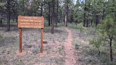
| This is the transition between the Coconino Rim & South Rim Passages along the AZT. |
 |
| Same shot, different side. |
 |
| We had to chuckle at the elevation profile...or lack thereof. Photo by Mike. |
 |
| The AZT descends gradually from Grandview to Tusayan some 14 miles away. |
 |
| Last time I was here this area was strewn with deadfall. Not today. Photo by Mike. |
 |
| Lots of color out there. Photo by Mike. |
What a great bikepacking route. If I were to do it again, probably will, I'd definitely drop water again at Moqui Stage Station only driving in/out via FS320/301. Start pedaling no later than 11a so you could camp at the metal Russell Tank area.
Thanks for driving, Mike, now get those windows fixed!!
Route:


