June 17, 2018

Picketpost: June Chills??

The stereotypical reply to someone complaining about the heat in these parts is: 'But it's a dry heat'. June often fits that description. It's hot, typically 105º - 115º, it's dry (<10% humidity) and it rarely if ever rains...until this year!! Cue our pal, Bud. Bud was a named Pacific Hurricane and we had the good fortune to lie in Bud's path as he fell apart. Keep in mind, it hadn't rained here since March 11th!! Yet here we were, mid-June, our driest and second hottest month and the forecast called for rain & 82º as the high.

I had planned to go ride on Saturday when the storm arrived, but I slept in a bit and when I woke we had a steady rain falling here in Queen Creek. So much so, that there were large puddles in our backyard. News worthy indeed. I opted to wait until Sunday to hit the trails, but where to go?

Most of our trail systems dry out quickly, but a few stay soggy for a day or so. Gold Canyon was out. I needed to stay kinda close to home...then it struck me. Picketpost. Yes. I had to take advantage of the good weather window.

I arrived at the trailhead around 5:30a and it was chilly!! Perfecto.
Early morning rays created quite the scene on Picketpost Mtn.

Water in the desert is fascinating.

Weaver's Needle pokes up along the horizon.

Different light angles this time of year really changed the landscape.

Any other time I've started a ride here before 6a, it would still be pitch black.

Picketpost Mtn. slipping below the saddle.

Century Plants in bloom.

Saguaro forest basking in the morning sunbeams.

I don't recall seeing Saguaro fruit before, the red through me off until I realized what it was.

I had planned to do an out-n-back to the 10 mile overlook, but I ran short on time. I opted to make a lollipop loop linking Telegraph Canyon Rd. back to the AZT via a horse trail instead.

These rock striations caught my attention.

Life finds a way to survive out here.

Quite a few large pools of water. This area received a bit of rain the day before.

Hero dirt along Telegraph Canyon Rd.

Turnoff to the horse trail connection. The trail was ok, best ridden the other direction, but it's only 0.6 miles long.

Saguaro fruit.

Back at the trailhead, it was maybe in the low 80's. I was only sweating because of the spike in humidity.
So glad I made to decision to head east to ride. The early morning light was really spectacular out there. I may try to ride there more often in the summer, just gotta get there early as it's mostly uphill the first 10 miles south.


Route:

June 10, 2018

Boone, NC

Boone, NC is such a nice summer getaway from the Phoenix heat. Now that we have family in the area, visits will be more frequent. I'm actually starting to get a sense of knowing my way around the surrounding area too.

We had initially planned on taking a red-eye flight, but the flight was nearing capacity and we weren't exactly near the top of the standby list. Plan B? Move up a flight and arrive earlier! This worked perfectly and we were driving away from Charlotte late on Thursday instead of Friday afternoon.

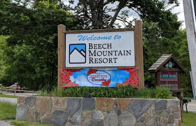
Let the brewery tour begin!! My in-laws are now retired and mostly do the snowbird thing between Boone & Tallahassee. They know where all the good local watering holes are. Our first stop would be new to them as well: Beech Mtn. Brewing Co.
One of the area ski resorts in the winter.

New brewery, take a flight.
The beers were pretty good, nothing really jumped out at any of us though. There also happens to be the Land of Oz theme park on site, of course K wants to come back for that.
We poked around the museum for a few minutes.

This scene freaked me out as a kid.

We're off to see the Wizard...

Oh, look, a mountain biker!! Yes, there are lift assisted trails to ride!! Next time.
It may not be a high Rocky Mountain pass of the west, but the elevation is enough to not really notice the higher humidity.

We made our way back over to Boone for a late lunch at Lost Province Brewing Co.

Impressive pizza oven.

Plenty to choose from.

Flight time!! The lager made with corn grits was interesting...in a good way.

Shrimp Po Boy & New Orleans kettle chips is fine southern eating!!
I love how the view from the porch changes by the minute. Storm clouds building.


I often wondered what all those peaks were, I knew about Rocky Knob (Mountain bike trails!!) I searched for a good Android App and found PeakFinder AR. $4.99 well spent in my book as it allows photos to be taken inside the app, then the overlay can be properly aligned if needed.
We had a few errands to run on Saturday mixed in with a couple more brewery stops.
We weren't planning a stop here, but found out their delicious Scottish Ale was back on draft. 

Appalachian Mountain Brewery in Boone.

Nice selection. Flight bound.

Cool mural above the bar.

Cheers!!
There was a food truck kinda attached to the building, portable kitchen!! The food was fantastic too.

Say whaa?? Yes, please. A couple packages were frozen for an AZ return.

Sunset from the porch.
Sunday was set aside for visiting with Gary's Aunt Sue. She comes to the mountains once a year, a nice getaway from the Charlotte area.
The gang out for brunch.

View from the Blue Ridge Parkway.

Sisters.

It's not often I get K to wear a biking shirt, Dr. Seuss sure helps!!

So many hills, bumps, peaks & layers of mountains. No idea how accurate this one is, but I'm sure it's close.

More porch time on a Sunday late afternoon. Great place to watch the birds & lightning bugs in the evening.

Gurgling waterfall at the bottom of the driveway.

Quite the mountain retreat!! New landscaping complete.

Yuengling brats cooked in Yuengling beer. Mmmm.

A couple heavy hitters we sampled.

A few that made their way back to AZ.
Boone is such a cool place to visit, especially when escaping the desert heat. We're already planning a longer stay next time, hopefully spending some time down in Asheville. Perhaps a ride...or two??


June 2, 2018

Prescott: Mixed Bag of Tricks

Mark and I had planned on doing an exploratory ride up in the Bradshaw mountains the first weekend in June, but the Prescott NF closed off sections of the forest and with it, some of our intended route. I gave Mark the task of coming up with another 25-30 mile route using some lesser traveled trails and preferably new-to-us dirt. Not a real easy task, but he was up to it.

I knocked out a few hours at work Friday morning, ran some errands then made my way to Prescott. We loaded up Mark's truck and went in search for a camping spot. We drove past one of the closed forest roads on our way up the mountain. To our surprise, Mark's choice spot was still vacant so we snagged it, yanked off the bikes and rode up to the overlook with 5 minutes to spare before sunset.
Golden Hour light in Arizona is something to behold.

Sierra Prieta overlook.

Dammit, I forgot my spraypaint. WTF is wrong with people??

Another day in the books.
Back at camp we set up Mark's absurdly over-engineered tent. Not sure I could set that thing up solo.

We didn't get as early a start as we would've liked, but neither one of us seemed eager to get moving in the wee hours of the morning. By the time we ate and were ready to ride, it was 9a. Oh well.
A few easy miles early on.

High above Thumb Butte, Humphrey's Peak way off on the horizon at 12,633'

West Spruce trail started out splendidly.
The trail morphed into a series of relatively short, punchy hike-a-bike sections for me...Mark rode everything. Ok, he did walk one super steep, chewed up switchback just so I knew he was human. That's one of many reasons I like going on rides with Mark, he tries to ride everything!! Usually does. Watching him power up some insanely steep grade makes me think I can at least give it a whirl. Sometimes I pull off the feat.

W. Spruce dumped out onto a section of the route with a disclaimer from Mark: 'Be warned', he said, 'I drew in this section based on satellite view'. Now, where have I heard that before?? I couldn't quite place it...

To our surprise this connector trail was an actual signed trail, Porter Mtn. Spur trail - #300, and was mostly downhill and rideable!! Win. We rejoined another forest road where it had been closed off to entry. Time for a snack break.

So far, the closure area had been very well marked.
We noted how rugged the road was, the one we were about to ride down, and joked how we'd doubt anyone drives up it. Barely 2 minutes later we heard a rumble, then a forest service employee came bouncing up the road. He was out patrolling the area to be sure the closure notices were being followed. We only noted two hikers a bit earlier, they too were obeying the rules.

Social trail connection.

NO campfires!!

Looks like we're back on a system trail.

On our way over to Spence Basin.

This section of the route was really fun, lots of downhill.

Saw our first group of riders near the bottom of Firewater trail. We didn't see many riders all day.

Rock outcroppings become more prominent as we enter Spence Basin.

Double step power!!

Random location for a car hood.

The aptly named Tunnel Vision trail's namesake.

Another namesake: Juniper Gate.

Giant rock slab with multiple lines to choose from.

It's stuff like this when I wish I had a dropper post. My Brooks saddle is too wide to get behind.

Alternate line.

What goes down, must surely go up.

We found the double black spur, Lloyd's Drop.

This was the upper section, a steep roller.

Followed by a 3' huck-to-flat.
The trails in Spence Basin were really fun. Plenty of rock features to play on, enough zigzagging to keep you on your toes too. 

Our route took us to the Thumb Butte TH where we topped off our water and chatted with another rider for a bit. It was mostly uphill back to the truck from here. Time to pay the piper.

Midway through the steady climb back to camp.

The entry to Sparrow trail was hardly noticeable, but the trail was easy to follow. The grade wasn't steep, but I was about at my limit for the day.

Naturally, after all the climbing, we found a sand trap at the top of the mountain barely 1/2 mile from the end.

Nature is neat. *Note to local yahoos, this is NOT a trash can.
This ride ended up being exactly what I needed. A good solid beatdown. I can tell my fitness has slacked off quite a bit with the lower mileage rides, etc. I'm ok with that...for now. I'm really itching for big miles once again. Thanks for putting together an awesome route, Mark. Until next time...


Route: