A couple weeks ago we were out at Picketpost to see first hand what the Telegraph Fire did to the trail corridor. I had hoped we'd have time to also recon Arnett Canyon afterwards, but we were epic'd by Mother Nature and barely had enough energy & light left that day.
So, I ventured out to Picketpost again. Naturally, since there was an excessive heat warning in effect for today I thought it would be wise to sleep in a bit and not get riding until 10a. You'd think after 30 years of living in the desert I'd know better. Nope. So what's another ride start with temps already hovering at 100º?? Not the first nor will it be the last and besides I was only planning to scope out Arnett Canyon, maybe 8-10 miles tops. What could possibly go wrong??
I arrived to an empty trailhead, shocking, right? Everything is so green right now, we've had a banner monsoon season this year, thankfully. Sometimes, a bit too much though as it's been raining fairly steady for the past two months until this week's heat spike. *Rain is scheduled to make a return next week.
 |
| While warm, the skies were clear & the ground green. |
 |
| Tis the season for caterpillars!! They're everywhere right now. |
 |
| Unintentional, but I think this Saguaro is giving Picketpost the finger. |
 |
| A short climb away from the AZT leads here, so glad this view is unchanged. |
 |
| So far, so good. I thought for sure this area was toast. |
 |
| Signage intact after the gate where the other side trail from the trailhead links up. |
 |
| Started to see some blackened Mesquite trees, but not much else. The first mile from the trailhead was unaffected by the fire. |
 |
| Down in the canyon the increase in sand was very noticeable. |
 |
| First creek crossing was blown out. Looks like a lot of water came through here. |
 |
| Where's the trail? Straight ahead. Soft, fine sand = walking. |
 |
| Ugh, there are the torched Saguaros, but it seemed those higher on the canyon walls were virtually untouched. |
 |
| Bummer. |
 |
| You can practically see the fire line only 20-30 feet up the slope. |
 |
| I spent a fair amount of time clearing dead, burnt branches from the tread. |
 |
| A good example of what to expect, burned floor and green sideslope. Mesquite trees will come back fairly quickly. |
 |
| I was encouraged to see a few tall Cottonwoods bearing leaves at the Arnett Creek crossing. |
 |
Looking upstream wasn't as promising.
|
 |
| Here's a 'before' shot of the image above. (April '19) |
 |
| A few trees made it though looking downstream. |
 |
| One of the more rideable sections of trail. |
 |
| South side of Picketpost Mtn. seems to be recovering well. I see pockets of thick trees up there!! |
 |
| Notice the palm tree on the left sprouting new fronds? |
 |
| Another 'before' shot of the general scene on the canyon floor. Mostly grass & Mesquite trees. See previous photo for the current view. (April '19) |
 |
| Found lots of this making things extra slow going. |
 |
| That's better. |
 |
| More of the same. |
 |
| This view made me sigh in relief!! After 1 1/4 miles of burned trail, the fire damage ended a few hundred feet before the giant grove of Cottonwood trees!! Yes!! |
 |
| The good news was quickly tempered by the flood damage. These debris piles are a ways up the creek drainage. |
 |
| It must've been one helluva sight to see how much water was flowing through here. Yowza. |
 |
| Arnett Creek staying above ground here. |
 |
| On the right bank, you can see how high the waterline was. Crazy. |
 |
| The aftermath of all that water, massive erosion ruts & large displaced logs!! |
 |
| This angle makes it appear as if all is well. |
 |
| Even some of the rock armored sections didn't survive. |
 |
| A few of the creek crossings were left in shambles. |
 |
| Backlog of debris right on the trail tread. |
 |
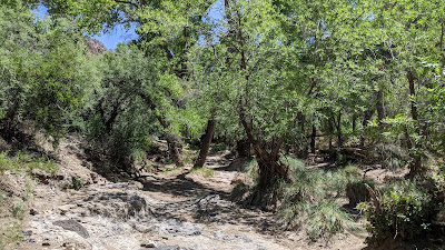
| One of the better images of the day: Big tall green trees, lots of healthy Saguaros and a good trail tread. |
 |
| It took me an hour & a half to cover those 2.7 miles!! Granted, I did some trail cleaning along the way, but the riding was slow!! |
 |
| Instead of backtracking, I turned left and rode up the side canyon. No worse for wear here. |
 |
| Down on the L.O.S.T. Queen Creek was flowing above ground here. |
I was running short on time and it was getting hot, so I made a beeline for US60, hopping a fence to gain access to the fast tarmac back to the trailhead.
 |
| I love these AZT progress signs along the length of the trail. What a great addition in recent years. |
 |
| One final iconic shot of Picketpost Mtn. |
As you can see, it was a mixed bag out there. I think the area will recover from the fire fairly quickly, but a lot of man hours will be needed to restore the trail tread. Not sure what can be done about the volume of sand that was deposited by the high flood waters. Hopefully trail usage will begin to disperse and pack it down over time. Arnett Canyon has a different feel to it now, but it's beauty is still unwavering.
Route:


No comments:
Post a Comment