Back in June one of our worst fears was realized in the parched desert: a spark. It began south of Superior and quickly spread enveloping one of the most beloved sections of the Arizona Trail: Alamo Canyon and a portion of the Gila River Canyons. Ugh. My heart ached as did many others who hold that area in high regard. It was a gut punch to say the least.
I made it known early that I wanted in on any scouting mission when the area was deemed safe for access. My buddy, Mike, was also game to join and Zach from the ATA put out some feelers on a date. We jumped at the opportunity. August 14 would be the day. The passage steward, Craig, and a buddy, Scott would also join in. What would we find? Total destruction or a fast moving light burn??
Mike and I made plans to drop a vehicle the night before down near Cochran which requires you to ford the Gila River, usually not a big deal. We figured it would be hot since it's August in the desert, but we could carry plenty of water for the 21 mile ride. We'd be starting at 5a and the final seven miles are almost all downhill.
Then the rains came...and didn't stop. The flowrate of the Gila River was spiking wildly in the days leading up to the ride. Crossing at 200 CFS is a challenge, almost waist deep on me at 6'1". It was reading 1300 CFS, 700 CFS, etc No way we're getting across that. Plan B?? We didn't feel a full ride out to Kelvin would be wise. The others had planned to do an out-n-back ride to the ATA rain collector, but the fire had burned another three miles farther and I wanted to see that too.
I looked at the topo maps of the area and saw we could shortcut over to the lower portion of the Picketpost Punisher route along the Brass Knuckles segment (Five rugged, steep up & downs along a jeep road) via Martinez Spring Rd which is essentially a dry wash. We'd then exit to our vehicle through Box Canyon. There would be some hike-a-bike down along the Brass Knuckles, but overall the route was 5-6 miles shorter than going to Kelvin.
The night before the ride the rains kept coming. Zach had camped at the trailhead and Mike and I met him a bit before 5a. The skies were clearing in the early dawn and the ground seemed dry enough to continue with the plan. Craig & Scott arrived and we got on the trail a bit after 5a. It was looking like a very comfortable day, forecast had it staying in the 80's which is virtually unheard of this time of year. Score. We hoped the cloud cover would hang around as well.
We were treated to a beautiful sunrise at the start.
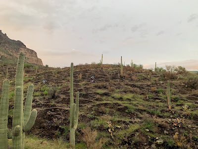
Looking south from the trailhead, you can see the charred hillsides.
First sign of the burn area: 0.5 miles south of Picketpost trailhead.
Craig is the regional steward of the Arizona Trail for this area. Photo by Zach.
Blackened hills, but green Saguaros!! Photo by Zach.
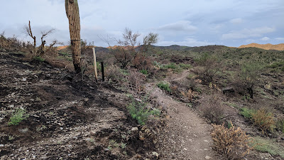
The trail tread was good so far.
We documented all the areas that need some attention. Here, a bit of erosion control is needed.
Sights like this were giving us hope as many of the Saguaros were green.
In fact, there was a lot of green out there. Rain has a way of doing that.
Catclaw beginning to encroach on the trail corridor. Photo by Zach.
This was one of the worst areas on the trail, near the equestrian trail split over to Telegraph Canyon. It's always been an issue here, but the rain has magnified it.
Burned or not, most of the hills were some shade of green.
Zach cranking away on his fatbike.
'What have I gotten myself into' Photo by Mike.
Did we transport to Ireland?? Photo by Zach.
March or August?? Even the wildflowers were confused.
Some areas were more stark than others.
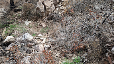
We cleared about two dozen burned Saguaro arms off the trail like the ones pictured.
There were hundreds of loose branches covering the trail too.
Different levels of burn visible here, right foreground was untouched by fire.
This was a welcomed sight. An entire hillside escaped the fire's wrath. Look at all those happy Saguaros!!
Six mile overlook with Telegraph Canyon Rd, FS4, in the distance.
We made our way towards the 5 tight switchbacks, keeping tabs on how many we could clear. I made 3 of 5, cleaning all the left-handed ones and failing on the righties.
Somewhere over the next rise, Scott's rear derailleur took a dump and he was reduced to Fred Flintstoning his bike back to Picketpost!! Gah. It wouldn't set up as a singlespeed as the chain was jacked up and would be too short. He and Craig bailed off the trail at Telegraph Canyon Rd. to shorten the trip back. Bummer.
Taking some time to shore up a drainage.
Mike moved a rock and found a scorpion hanging out.
Mike descends towards Telegraph Canyon Rd. Photo by Zach.
This is the wash just beyond Telegraph Canyon Rd. It had been a popular place for thru-hikers to camp.
Over the next two miles we noticed more devastation from the fire. The landscape was obliterated.
Not much survived here.
Total moonscape.
The fellas clearing more debris.
This area is roughly 8 miles south of Picketpost trailhead.
Heavy rains over the burn area expedite erosion. Photo by Zach.
This particular area was especially sad to see...
Here's a 'before' shot from a few years ago.
Before & after. However, we could already see new tree growth occurring. Photo by Zach.
Snake cartilage, not all the critters escaped.
Not much left of this giant Cholla.
New bike was riding great, except I was having an issue with the fork...
Leaking air in the chamber, pushing out the dust cover. Luckily, Zach had a shock pump for the rest of the ride. Looks like a warranty item. Dang it.
We're heading towards that notch just left of center.
View to the east from the 10 mile overlook.
Tank filled.
I've never seen water flowing in this wash.
The water retreats underground here.
Taking the offshoot to the rain collector.
No damage here, the fire got close but that was it.
The area around the collector was filled with grass and the couple of mesquite trees were unharmed. The collector was overflowing with water. Zach unlocked the side door to check inside, as the main water tank is inside this outer metal shell, and found a Gila Monster walking around!! How cool. Looks like that fella found a great place to call home. We all topped off our water. This is where Zach turned around and Mike and I continued on.
Only the second time I've seen water in this tank in Martinez Canyon.
One thing the fire didn't do? Ruin the splendor of Martinez. It'll take more than burned vegetation to do that.
The rocks & views are the main attraction here.
More water!! Never seen this one flowing.
The fire ripped down this drainage.
Lots of debris to clear.
We were able to drag a few large Saguaros off the trail.
Still as amazing as ever.
We truly are miniscule in this landscape.
The cloud cover had been cooperating all day. Photo by Mike.
We figured there was a good chance we'd get rained on in the afternoon. I thought we may be finished by 2 or 3, but it took us 5 hours to reach the rain collector and another 2 hours to get to the saddle after Martinez Canyon. We weren't quite halfway done with our ride and had been at it for 7 hours. I left my rain jacket in the car intentionally, figuring if it rained, it would feel good in the warm temps. One less thing to carry, right? Plus, that almost guarantees it's going to rain.
Traversing across the saddle.
Looking back into Martinez Canyon, clouds building.
Nice to see bushy Ocotillos along here.
Brooding skies are now ominous. Can we out-ride the incoming storm? We are about to head downhill for a few fast miles.
The Martinez Saddle, beginning of the 7 mile descent to the Gila River. Now with less Cholla!! *They'll grow back soon enough.
I love this section and was glad to see only a light burn through it.
Barely a half a mile from the previous picture to here and we're now officially out of the burn area.
The only deadfall we couldn't clear, but this one's been here a while.
A light rain begins to fall.
So glad this fella didn't get torched. Two thumbs up!!
Shortly after Mr. Two Thumbs Up, the skies opened up. A torrential downpour ensued and didn't let up for a solid 45 minutes. The AZT through here is mostly compacted rock, and it rode great in the deluge. Mike and I were soaked and loving it even though our brakes were marginal at best. Ha!
Dale's Butte can barely be seen through the downpour.
Just out for a ride, getting our #locorides passport renewed.
We reached the junction with a jeep road near Dale's Butte and turned right, off the AZT. As we descended more and more rivulets formed, we crossed a couple of small flowing washes then reached our main wash/road we'd be following...
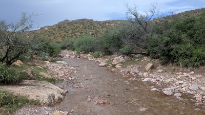
Martinez Spring Rd. errrr....creek!!
Water, water, everywhere!!
We began spotting small waterfalls everywhere.
For the most part we could pedal downstream.
Eventually, the creek narrowed a bit and became a bit too strong to feel comfortable continuing on in it. We followed some game trails next to the creek for a bit then once it widened and the rain slowed, we could once again ride down the flowing road.
Dale's Butte now visible and some blue sky!!
We were following the creek and I noticed it was going straight into a retaining basing, time to exit!! We hopped out and began following another dry jeep road, but it soon had us off-route. We backtracked, then bushwhacked a short bit to regain the track. I recalled when I put the route together there was a vague 2-track on satellite view. This was it:
That's our route. Follow that for the next mile. We ended up crossing the creek a few times before finally reaching the main 4x4 route aka: Brass Knuckles.
Each wash we encountered was flowing. It was wonderful to witness.
The desert is so happy!!
We assumed Zach had a similar fate as us on his way back to Picketpost. Photo by Mike.
This is a portion of the Brass Knuckles. A series of five steep ups & downs on rugged jeep roads. Going this direction, we only had to do four of them. There was plenty of hike-a-bike. Photo by Mike.
Entering Box Canyon and what is this? A huge waterfall!!
Water was flowing down the Box too. Photo by Mike.
What an incredible sight!! I wonder how long this waterfall exists? Talk about perfect timing.
One of the tight sections in Box Canyon.
Mike spotted this Gray Fox near another waterfall. Took him a while to notice we were watching him.
The water attractions kept coming. Photo by Mike.
A little bit of slickrock riding.
We did find a few patches to ride that weren't under water.
Water levels increased when we passed a side canyon with a large feeder creek. Photo by Mike.
We were now riding in water all the way out of Box Canyon and beyond. Photo by Mike.
A dry bit!! Some sections had fine gravel and I sunk in deep enough that pedaling was difficult. Photo by Mike.
Somewhere along here I began to semi-bonk. My snack feedbag isn't exactly waterproof, so all my almonds, Payday bar bits, Clif bar chunks were covered in a slimy gel of gooey Clif Shot Bloks and Sour Patch Kids. Freakin' delicious!! I stopped and gorged on the concoction for a minute and then caught up with Mike with a bit more energy.
Almost 11 hours into our day and we see our first trail users. Like us, out playing in the water.
By now we had mostly dried out, sans shoes/socks. Only fitting to catch a rainbow over our route. Photo by Mike.
One final shot looking back towards Box Canyon.
Our route would eventually turn away from the water runout and we wrapped up our ride on dry road. It took nearly 12 hours to cover the 31 miles!! In the end it was a very successful ride. The fire damage wasn't nearly as bad as we feared, the tread is in fairly good shape all things considered and it's clear of debris for the time being. The downpour over the back end of the ride was such a treat as we were able to witness the desert like few have seen. It was a good wildlife sighting day too.
Thanks to Zach at the ATA for putting this together. Thanks to the other fellas, Mike, Craig & Scott for coming out to lend a hand in clearing the trail. All hands were needed. Mike, thanks for coming out a day early to drop your truck off at the finish, we sure made the right call in mixing up our original route plans, eh?.
This is an amazing post about the extent of the fire. Thanks for your hard work. We hiked part of Arnett Canyon yesterday and were shocked by the fire damage.
Thank you!! Glad you found it informative. I recently rode through Arnett Canyon again and thought it was in much better condition than two months ago. It's beginning to heal!!


This is an amazing post about the extent of the fire. Thanks for your hard work. We hiked part of Arnett Canyon yesterday and were shocked by the fire damage.
ReplyDeleteThank you!! Glad you found it informative. I recently rode through Arnett Canyon again and thought it was in much better condition than two months ago. It's beginning to heal!!
Delete